Providencia de Pérez geodata
Providencia de Pérez (Guanajuato) is a populated place; located in Mexico in America/Mexico_City (GMT-6) time zone. With population of 994 people, there are 8763 cities with bigger population in this country. Compared to other cities in Mexico, 70.1% of cities are located further ↓South; 76.7% of cities are located further →East and 60% of cities have lower elevation than Providencia de Pérez. Note1
Current local time in Providencia de Pérez:
08:30 AM, WednesdayDifference from your time zone: hours


Providencia de Pérez GPS coordinates[2]
20° 36' 20.448" North, 101° 25' 32.772" West
| Map corner | latitude | longitude |
|---|---|---|
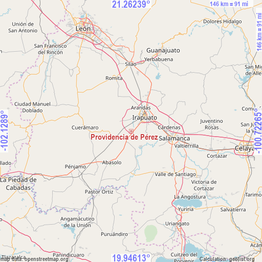
| Upper-left | 21.26239°, | -102.1289° |
| Center: | 20.60568°, | -101.42577° |
| Lower-right: | 19.94613°, | -100.72265° |
| Map W x H: | 146.4×146.4 km | = 91×91mi |
| max Lat: | 32.7° ⇑29.9% North |
| Providencia de Pérez: | 20.60568° |
| min Lat: | ⇓70.1% South 14.53588° |
| min Long | Providencia de | max Long |
| -117.105° | -101.42577° | -86.73105° |
| W 23.3%⇐ | ⇒76.7% E |
Elevation
Elevation of Providencia de Pérez is 1725 m = 5659 ft, and this is 471.3 m = 1546 ft above average elevation for this country.
| Max E: |
3497 m = 11473 ft | 40% |
| Providencia de Pérez | 1725 m 5659 ft | |
| Avg. | 1253.7 m = 4113 ft | |
Min E: |
-1 m = -3 ft | 60% |
See also: Mexico elevation on elevation.city.
Geographical zone
Providencia de Pérez is located in North Torrid zone (between Equator and Tropic of Cancer). Distance of this Northern Tropic circle is 314.8 km =195.6 mi to North.| Distance of | km | miles | from Providencia de Pérez |
|---|---|---|---|
| North Pole | 7715.9 | 4794.4 | to North |
| Arctic Circle | 5110 | 3175.2 | to North |
| Tropic Cancer | 314.8 | 195.6 | to North |
| Equator | 2291.1 | 1423.6 | to South |


Nearby cities:
15 places around Providencia de Pérez: (largest is in red/bold)
• Colonia Morelos de Guadalupe de Rivera
2.6 km =1.6 mi,  244°
244°
• El Romeral
4.5 km =2.8 mi,  234°
234°
• Fraccionamiento las Liebres
5.6 km =3.5 mi,  34°
34°
• Guadalupe de Rivera
4.3 km =2.7 mi,  268°
268°
• La Soledad
1.1 km =0.7 mi,  76°
76°
• Las Huertas Tercera Sección
6.2 km =3.9 mi, 33°
• Purísima de Covarrubias
6.2 km =3.9 mi,  284°
284°
• Rancho Nuevo de Dolores (El Cuero)
2.7 km =1.7 mi, 25°
• Rivera de Guadalupe
3.7 km =2.3 mi, 282°
• San Agustín el Alto (La Araña)
5.4 km =3.4 mi,  99°
99°
• San José de Bernalejo (El Guayabo)
4.6 km =2.9 mi, 33°
• San Luis del Jánamo (El Morado)
3.5 km =2.2 mi, 237°
• San Miguel del Brete
6.1 km =3.8 mi,  193°
193°
• Tomelopitos
6.1 km =3.8 mi, 101°
• Villa de Guadalupe
6.3 km =3.9 mi,  133°
133°
Sources, notices
• [Note1] Compared only with cities in Mexico existing in our database
• [Src1] Map data: © OpenStreetMap contributors (CC-BY-SA)
• [Src2] Other city data from geonames.org with taken over terms of usage.
• [Src3] Geographical zone / Annual Mean Temperature by Robert A. Rohde @ Wikipedia
