Tejamanil geodata
Tejamanil (Guanajuato) is a populated place; located in Mexico in America/Mexico_City (GMT-6) time zone. With population of 908 people, there are 9617 cities with bigger population in this country. Compared to other cities in Mexico, 72.9% of cities are located further ↓South; 77.4% of cities are located further →East and 60.6% of cities have lower elevation than Tejamanil. Note1


Tejamanil GPS coordinates[2]
20° 46' 33.204" North, 101° 29' 45.96" West
| Map corner | latitude | longitude |
|---|---|---|
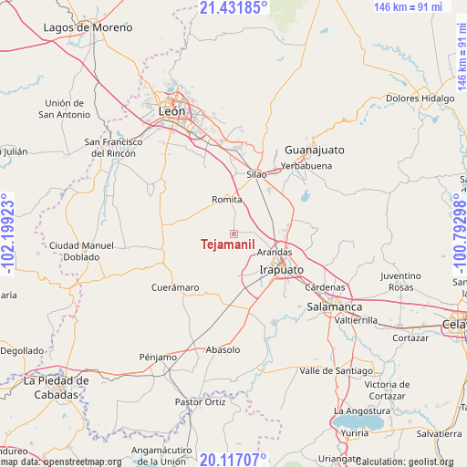
| Upper-left | 21.43185°, | -102.19923° |
| Center: | 20.77589°, | -101.4961° |
| Lower-right: | 20.11707°, | -100.79298° |
| Map W x H: | 146.2×146.2 km | = 90.8×90.8mi |
| max Lat: | 32.7° ⇑27.1% North |
| Tejamanil: | 20.77589° |
| min Lat: | ⇓72.9% South 14.53588° |
| min Long | Tejamanil | max Long |
| -117.105° | -101.4961° | -86.73105° |
| W 22.6%⇐ | ⇒77.4% E |
Elevation
Elevation of Tejamanil is 1736 m = 5696 ft, and this is 482.3 m = 1582 ft above average elevation for this country.
| Max E: |
3497 m = 11473 ft | 39.4% |
| Tejamanil | 1736 m 5696 ft | |
| Avg. | 1253.7 m = 4113 ft | |
Min E: |
-1 m = -3 ft | 60.6% |
See also: Mexico elevation on elevation.city.
Geographical zone
Tejamanil is located in North Torrid zone (between Equator and Tropic of Cancer). Distance of this Northern Tropic circle is 295.9 km =183.9 mi to North.| Distance of | km | miles | from Tejamanil |
|---|---|---|---|
| North Pole | 7697 | 4782.7 | to North |
| Arctic Circle | 5091.1 | 3163.5 | to North |
| Tropic Cancer | 295.9 | 183.9 | to North |
| Equator | 2310.1 | 1435.4 | to South |


Nearby cities:
15 places around Tejamanil: (largest is in red/bold)
• El Carmen de Sánchez
7.5 km =4.7 mi,  281°
281°
• El Conejo
9.3 km =5.8 mi,  123°
123°
• Guadalupe de Paso Blanco
9.9 km =6.2 mi,  103°
103°
• La Caja
9.4 km =5.8 mi,  139°
139°
• Las Liebres
7.1 km =4.4 mi,  21°
21°
• Maravillas de las Victorias
9 km =5.6 mi, 17°
• Mezquite Gordo
4.3 km =2.7 mi,  4°
4°
• Noria de Camarena
7.1 km =4.4 mi, 122°
• Romita
10.8 km =6.7 mi,  348°
348°
• San Clemente
6.1 km =3.8 mi,  310°
310°
• San Miguel del Guaricho
8.5 km =5.3 mi,  329°
329°
• Santa Bárbara
9.6 km =6 mi,  77°
77°
• Santa Rosa de Rivas
4.2 km =2.6 mi, 277°
• Serrano
10.5 km =6.5 mi,  88°
88°
• Vista Hermosa
3.4 km =2.1 mi,  220°
220°
Sources, notices
• [Note1] Compared only with cities in Mexico existing in our database
• [Src1] Map data: © OpenStreetMap contributors (CC-BY-SA)
• [Src2] Other city data from geonames.org with taken over terms of usage.
• [Src3] Geographical zone / Annual Mean Temperature by Robert A. Rohde @ Wikipedia
