Mezquite Gordo geodata
Mezquite Gordo (Guanajuato) is a populated place; located in Mexico in America/Mexico_City (GMT-6) time zone. With population of 1,723 people, there are 5036 cities with bigger population in this country. Compared to other cities in Mexico, 73.5% of cities are located further ↓South; 77.4% of cities are located further →East and 60.8% of cities have lower elevation than Mezquite Gordo. Note1


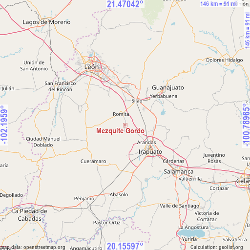
Mezquite Gordo GPS coordinates[2]
20° 48' 52.668" North, 101° 29' 33.972" West
| Map corner | latitude | longitude |
|---|---|---|
| Upper-left | 21.47042°, | -102.1959° |
| Center: | 20.81463°, | -101.49277° |
| Lower-right: | 20.15597°, | -100.78965° |
| Map W x H: | 146.2×146.2 km | = 90.8×90.8mi |
| max Lat: | 32.7° ⇑26.5% North |
| Mezquite Gordo: | 20.81463° |
| min Lat: | ⇓73.5% South 14.53588° |
| min Long | Mezquite Gordo | max Long |
| -117.105° | -101.49277° | -86.73105° |
| W 22.6%⇐ | ⇒77.4% E |
Elevation
Elevation of Mezquite Gordo is 1741 m = 5712 ft, and this is 487.3 m = 1599 ft above average elevation for this country.
| Max E: |
3497 m = 11473 ft | 39.2% |
| Mezquite Gordo | 1741 m 5712 ft | |
| Avg. | 1253.7 m = 4113 ft | |
Min E: |
-1 m = -3 ft | 60.8% |
See also: Mexico elevation on elevation.city.
Geographical zone
Mezquite Gordo is located in North Torrid zone (between Equator and Tropic of Cancer). Distance of this Northern Tropic circle is 291.5 km =181.1 mi to North.| Distance of | km | miles | from Mezquite Gordo |
|---|---|---|---|
| North Pole | 7692.7 | 4780 | to North |
| Arctic Circle | 5086.8 | 3160.8 | to North |
| Tropic Cancer | 291.5 | 181.1 | to North |
| Equator | 2314.4 | 1438.1 | to South |


Nearby cities:
15 places around Mezquite Gordo: (largest is in red/bold)
• El Carmen de Sánchez
8.2 km =5.1 mi,  249°
249°
• El Mármol
9.6 km =6 mi,  290°
290°
• La Aldea
9.8 km =6.1 mi,  8°
8°
• Las Liebres
3.3 km =2.1 mi,  45°
45°
• Los Medranos
9.6 km =6 mi,  37°
37°
• Maravillas de las Victorias
4.9 km =3 mi,  29°
29°
• Noria de Camarena
9.8 km =6.1 mi,  144°
144°
• Romita
6.8 km =4.2 mi,  338°
338°
• San Clemente
5 km =3.1 mi,  266°
266°
• San Francisco Puerta Grande
6.9 km =4.3 mi, 7°
• San Miguel del Guaricho
5.5 km =3.4 mi,  302°
302°
• Santa Bárbara
9.4 km =5.8 mi,  104°
104°
• Santa Rosa de Rivas
5.9 km =3.7 mi,  230°
230°
• Tejamanil
4.3 km =2.7 mi,  184°
184°
• Vista Hermosa
7.3 km =4.5 mi,  200°
200°
Sources, notices
• [Note1] Compared only with cities in Mexico existing in our database
• [Src1] Map data: © OpenStreetMap contributors (CC-BY-SA)
• [Src2] Other city data from geonames.org with taken over terms of usage.
• [Src3] Geographical zone / Annual Mean Temperature by Robert A. Rohde @ Wikipedia
