Las Liebres geodata
Las Liebres (Guanajuato) is a populated place; located in Mexico in America/Mexico_City (GMT-6) time zone. With population of 1,184 people, there are 7340 cities with bigger population in this country. Compared to other cities in Mexico, 73.8% of cities are located further ↓South; 77.2% of cities are located further →East and 61.1% of cities have lower elevation than Las Liebres. Note1


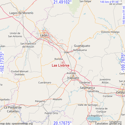
Las Liebres GPS coordinates[2]
20° 50' 7.152" North, 101° 28' 14.232" West
| Map corner | latitude | longitude |
|---|---|---|
| Upper-left | 21.49102°, | -102.17375° |
| Center: | 20.83532°, | -101.47062° |
| Lower-right: | 20.17675°, | -100.7675° |
| Map W x H: | 146.1×146.1 km | = 90.8×90.8mi |
| max Lat: | 32.7° ⇑26.2% North |
| Las Liebres: | 20.83532° |
| min Lat: | ⇓73.8% South 14.53588° |
| min Long | Las Liebres | max Long |
| -117.105° | -101.47062° | -86.73105° |
| W 22.8%⇐ | ⇒77.2% E |
Elevation
Elevation of Las Liebres is 1745 m = 5725 ft, and this is 491.3 m = 1612 ft above average elevation for this country.
| Max E: |
3497 m = 11473 ft | 38.9% |
| Las Liebres | 1745 m 5725 ft | |
| Avg. | 1253.7 m = 4113 ft | |
Min E: |
-1 m = -3 ft | 61.1% |
See also: Mexico elevation on elevation.city.
Geographical zone
Las Liebres is located in North Torrid zone (between Equator and Tropic of Cancer). Distance of this Northern Tropic circle is 289.2 km =179.7 mi to North.| Distance of | km | miles | from Las Liebres |
|---|---|---|---|
| North Pole | 7690.4 | 4778.6 | to North |
| Arctic Circle | 5084.5 | 3159.4 | to North |
| Tropic Cancer | 289.2 | 179.7 | to North |
| Equator | 2316.7 | 1439.5 | to South |


Nearby cities:
15 places around Las Liebres: (largest is in red/bold)
• Colonia Rafael Corrales Ayala
8.8 km =5.5 mi,  327°
327°
• La Aldea
7.4 km =4.6 mi,  353°
353°
• Los Medranos
6.4 km =4 mi,  33°
33°
• Maravillas de las Victorias
1.9 km =1.2 mi,  1°
1°
• Mezquite Gordo
3.3 km =2.1 mi,  225°
225°
• Romita
6.2 km =3.9 mi,  309°
309°
• San Clemente
7.8 km =4.8 mi,  250°
250°
• San Diego
8.7 km =5.4 mi,  46°
46°
• San Francisco Puerta Grande
4.7 km =2.9 mi,  343°
343°
• San Isidro del Arenal
8.4 km =5.2 mi,  23°
23°
• San José de Gracia
7.4 km =4.6 mi, 19°
• San Miguel del Guaricho
7 km =4.3 mi,  275°
275°
• Santa Bárbara
8.2 km =5.1 mi,  124°
124°
• Santa Rosa de Rivas
9.1 km =5.7 mi, 228°
• Tejamanil
7.1 km =4.4 mi,  201°
201°
Sources, notices
• [Note1] Compared only with cities in Mexico existing in our database
• [Src1] Map data: © OpenStreetMap contributors (CC-BY-SA)
• [Src2] Other city data from geonames.org with taken over terms of usage.
• [Src3] Geographical zone / Annual Mean Temperature by Robert A. Rohde @ Wikipedia
