Hacienda de Márquez geodata
Hacienda de Márquez (Guanajuato) is a populated place; located in Mexico in America/Mexico_City (GMT-6) time zone. With population of 2,279 people, there are 3865 cities with bigger population in this country. Compared to other cities in Mexico, 73% of cities are located further ↓South; 76.1% of cities are located further →East and 61.3% of cities have lower elevation than Hacienda de Márquez. Note1


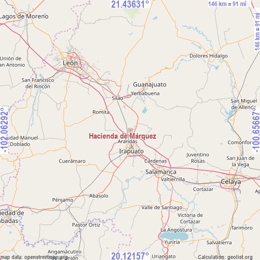
Hacienda de Márquez GPS coordinates[2]
20° 46' 49.332" North, 101° 21' 35.244" West
| Map corner | latitude | longitude |
|---|---|---|
| Upper-left | 21.43631°, | -102.06292° |
| Center: | 20.78037°, | -101.35979° |
| Lower-right: | 20.12157°, | -100.65667° |
| Map W x H: | 146.2×146.2 km | = 90.8×90.8mi |
| max Lat: | 32.7° ⇑27% North |
| Hacienda de Márquez: | 20.78037° |
| min Lat: | ⇓73% South 14.53588° |
| min Long | Hacienda de Má | max Long |
| -117.105° | -101.35979° | -86.73105° |
| W 23.9%⇐ | ⇒76.1% E |
Elevation
Elevation of Hacienda de Márquez is 1748 m = 5735 ft, and this is 494.3 m = 1622 ft above average elevation for this country.
| Max E: |
3497 m = 11473 ft | 38.7% |
| Hacienda de Márquez | 1748 m 5735 ft | |
| Avg. | 1253.7 m = 4113 ft | |
Min E: |
-1 m = -3 ft | 61.3% |
See also: Mexico elevation on elevation.city.
Geographical zone
Hacienda de Márquez is located in North Torrid zone (between Equator and Tropic of Cancer). Distance of this Northern Tropic circle is 295.4 km =183.6 mi to North.| Distance of | km | miles | from Hacienda de Márquez |
|---|---|---|---|
| North Pole | 7696.5 | 4782.4 | to North |
| Arctic Circle | 5090.6 | 3163.2 | to North |
| Tropic Cancer | 295.4 | 183.6 | to North |
| Equator | 2310.6 | 1435.7 | to South |


Nearby cities:
15 places around Hacienda de Márquez: (largest is in red/bold)
• Ex-Hacienda del Copal
5.1 km =3.2 mi,  149°
149°
• Guadalupe Villa Cárdenas
6.1 km =3.8 mi,  8°
8°
• Guadalupe de Paso Blanco
5.3 km =3.3 mi,  238°
238°
• La Calera
3.7 km =2.3 mi,  51°
51°
• La Garrida
3.5 km =2.2 mi,  180°
180°
• Lo de Juárez
2.4 km =1.5 mi,  124°
124°
• Molino de Santa Ana
5.5 km =3.4 mi, 11°
• Nueva Colonia Copalillo (El Atorón)
3.6 km =2.2 mi,  206°
206°
• Purísima del Progreso
3.4 km =2.1 mi,  64°
64°
• Rancho Nuevo del Llanito
4.9 km =3 mi,  349°
349°
• San Antonio el Rico
4.9 km =3 mi, 345°
• San Vicente
5.7 km =3.5 mi,  19°
19°
• Santa Bárbara
5 km =3.1 mi,  287°
287°
• Serrano
3.7 km =2.3 mi,  266°
266°
• Taretán
2.6 km =1.6 mi,  93°
93°
Sources, notices
• [Note1] Compared only with cities in Mexico existing in our database
• [Src1] Map data: © OpenStreetMap contributors (CC-BY-SA)
• [Src2] Other city data from geonames.org with taken over terms of usage.
• [Src3] Geographical zone / Annual Mean Temperature by Robert A. Rohde @ Wikipedia
