San Antonio Eménguaro geodata
San Antonio Eménguaro (Guanajuato) is a populated place; located in Mexico in America/Mexico_City (GMT-6) time zone. With population of 1,061 people, there are 8225 cities with bigger population in this country. Compared to other cities in Mexico, 60% of cities are located further ↓South; 72.4% of cities are located further →East and 64.3% of cities have lower elevation than San Antonio Eménguaro. Note1
Current local time in San Antonio Eménguaro:
03:40 AM, WednesdayDifference from your time zone: hours


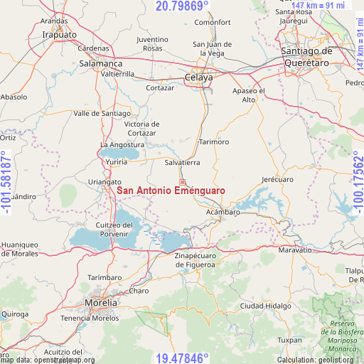
San Antonio Eménguaro GPS coordinates[2]
20° 8' 23.892" North, 100° 52' 43.464" West
| Map corner | latitude | longitude |
|---|---|---|
| Upper-left | 20.79869°, | -101.58187° |
| Center: | 20.13997°, | -100.87874° |
| Lower-right: | 19.47846°, | -100.17562° |
| Map W x H: | 146.8×146.8 km | = 91.2×91.2mi |
| max Lat: | 32.7° ⇑40% North |
| San Antonio Eménguaro: | 20.13997° |
| min Lat: | ⇓60% South 14.53588° |
| min Long | San Antonio Em� | max Long |
| -117.105° | -100.87874° | -86.73105° |
| W 27.6%⇐ | ⇒72.4% E |
Elevation
Elevation of San Antonio Eménguaro is 1809 m = 5935 ft, and this is 555.3 m = 1822 ft above average elevation for this country.
| Max E: |
3497 m = 11473 ft | 35.7% |
| San Antonio Eménguaro | 1809 m 5935 ft | |
| Avg. | 1253.7 m = 4113 ft | |
Min E: |
-1 m = -3 ft | 64.3% |
See also: Mexico elevation on elevation.city.
Geographical zone
San Antonio Eménguaro is located in North Torrid zone (between Equator and Tropic of Cancer). Distance of this Northern Tropic circle is 366.6 km =227.8 mi to North.| Distance of | km | miles | from San Antonio Eménguaro |
|---|---|---|---|
| North Pole | 7767.7 | 4826.6 | to North |
| Arctic Circle | 5161.8 | 3207.4 | to North |
| Tropic Cancer | 366.6 | 227.8 | to North |
| Equator | 2239.4 | 1391.5 | to South |


Nearby cities:
15 places around San Antonio Eménguaro: (largest is in red/bold)
• Chamácuaro
6.6 km =4.1 mi,  126°
126°
• Estancia del Carmen de Maravatío
5.5 km =3.4 mi,  231°
231°
• La Palma de Eménguaro
1.8 km =1.1 mi,  278°
278°
• La Virgen
2.7 km =1.7 mi,  274°
274°
• Las Cruces
11.2 km =7 mi,  246°
246°
• Las Jícamas
9.3 km =5.8 mi,  156°
156°
• Maravatío del Encinal
11.3 km =7 mi,  309°
309°
• Obrajuelo
4.7 km =2.9 mi,  139°
139°
• Ojo de Agua de Ballesteros
11.3 km =7 mi,  30°
30°
• Salvatierra
8.1 km =5 mi,  358°
358°
• San Miguel Eménguaro
2.8 km =1.7 mi,  344°
344°
• San Pedro de los Naranjos
11.5 km =7.1 mi,  327°
327°
• Santa Teresa (La Majada)
9.8 km =6.1 mi,  300°
300°
• Santo Tomás Huatzindeo
10.1 km =6.3 mi, 334°
• Urireo
9 km =5.6 mi, 25°
Sources, notices
• [Note1] Compared only with cities in Mexico existing in our database
• [Src1] Map data: © OpenStreetMap contributors (CC-BY-SA)
• [Src2] Other city data from geonames.org with taken over terms of usage.
• [Src3] Geographical zone / Annual Mean Temperature by Robert A. Rohde @ Wikipedia
