Las Jícamas geodata
Las Jícamas (Guanajuato) is a populated place; located in Mexico in America/Mexico_City (GMT-6) time zone. With population of 776 people, there are 11259 cities with bigger population in this country. Compared to other cities in Mexico, 58.4% of cities are located further ↓South; 72.2% of cities are located further →East and 68.4% of cities have lower elevation than Las Jícamas. Note1


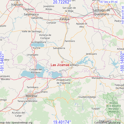
Las Jícamas GPS coordinates[2]
20° 3' 48.852" North, 100° 50' 35.304" West
| Map corner | latitude | longitude |
|---|---|---|
| Upper-left | 20.72262°, | -101.54627° |
| Center: | 20.06357°, | -100.84314° |
| Lower-right: | 19.40174°, | -100.14002° |
| Map W x H: | 146.9×146.9 km | = 91.3×91.3mi |
| max Lat: | 32.7° ⇑41.6% North |
| Las Jícamas: | 20.06357° |
| min Lat: | ⇓58.4% South 14.53588° |
| min Long | Las Jícamas | max Long |
| -117.105° | -100.84314° | -86.73105° |
| W 27.8%⇐ | ⇒72.2% E |
Elevation
Elevation of Las Jícamas is 1897 m = 6224 ft, and this is 643.3 m = 2111 ft above average elevation for this country.
| Max E: |
3497 m = 11473 ft | 31.6% |
| Las Jícamas | 1897 m 6224 ft | |
| Avg. | 1253.7 m = 4113 ft | |
Min E: |
-1 m = -3 ft | 68.4% |
See also: Mexico elevation on elevation.city.
Geographical zone
Las Jícamas is located in North Torrid zone (between Equator and Tropic of Cancer). Distance of this Northern Tropic circle is 375.1 km =233.1 mi to North.| Distance of | km | miles | from Las Jícamas |
|---|---|---|---|
| North Pole | 7776.2 | 4831.9 | to North |
| Arctic Circle | 5170.3 | 3212.7 | to North |
| Tropic Cancer | 375.1 | 233.1 | to North |
| Equator | 2230.9 | 1386.2 | to South |


Nearby cities:
15 places around Las Jícamas: (largest is in red/bold)
• Andocutín
12.2 km =7.6 mi,  191°
191°
• Chamácuaro
4.8 km =3 mi,  19°
19°
• Estancia del Carmen de Maravatío
9.5 km =5.9 mi,  302°
302°
• La Merced
5.1 km =3.2 mi,  137°
137°
• La Palma de Eménguaro
10.4 km =6.5 mi,  327°
327°
• La Virgen
10.8 km =6.7 mi,  323°
323°
• Monte Prieto
6.8 km =4.2 mi,  69°
69°
• Obrajuelo
5 km =3.1 mi,  352°
352°
• Parácuaro
12.2 km =7.6 mi,  42°
42°
• San Antonio Eménguaro
9.3 km =5.8 mi,  336°
336°
• San Diego de Alcalá
4.2 km =2.6 mi,  210°
210°
• San Juan Jaripeo
10.7 km =6.6 mi,  126°
126°
• San Juan Viejo
10.4 km =6.5 mi, 70°
• San Miguel Eménguaro
12 km =7.5 mi, 338°
• San Pablo Pejo
10.4 km =6.5 mi,  251°
251°
Sources, notices
• [Note1] Compared only with cities in Mexico existing in our database
• [Src1] Map data: © OpenStreetMap contributors (CC-BY-SA)
• [Src2] Other city data from geonames.org with taken over terms of usage.
• [Src3] Geographical zone / Annual Mean Temperature by Robert A. Rohde @ Wikipedia
