La Madeja geodata
La Madeja (Guanajuato) is a populated place; located in Mexico in America/Mexico_City (GMT-6) time zone. With population of 666 people, there are 13039 cities with bigger population in this country. Compared to other cities in Mexico, 66.5% of cities are located further ↓South; 80.6% of cities are located further →East and 58.5% of cities have lower elevation than La Madeja. Note1


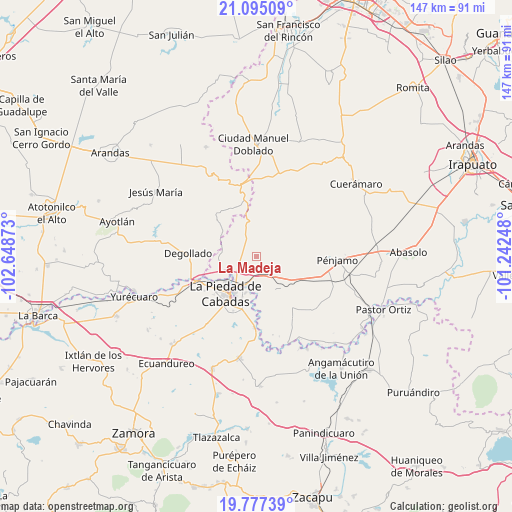
La Madeja GPS coordinates[2]
20° 26' 15.54" North, 101° 56' 44.16" West
| Map corner | latitude | longitude |
|---|---|---|
| Upper-left | 21.09509°, | -102.64873° |
| Center: | 20.43765°, | -101.9456° |
| Lower-right: | 19.77739°, | -101.24248° |
| Map W x H: | 146.5×146.5 km | = 91×91mi |
| max Lat: | 32.7° ⇑33.5% North |
| La Madeja: | 20.43765° |
| min Lat: | ⇓66.5% South 14.53588° |
| min Long | La Madeja | max Long |
| -117.105° | -101.9456° | -86.73105° |
| W 19.4%⇐ | ⇒80.6% E |
Elevation
Elevation of La Madeja is 1698 m = 5571 ft, and this is 444.3 m = 1458 ft above average elevation for this country.
| Max E: |
3497 m = 11473 ft | 41.5% |
| La Madeja | 1698 m 5571 ft | |
| Avg. | 1253.7 m = 4113 ft | |
Min E: |
-1 m = -3 ft | 58.5% |
See also: Mexico elevation on elevation.city.
Geographical zone
La Madeja is located in North Torrid zone (between Equator and Tropic of Cancer). Distance of this Northern Tropic circle is 333.5 km =207.2 mi to North.| Distance of | km | miles | from La Madeja |
|---|---|---|---|
| North Pole | 7734.6 | 4806.1 | to North |
| Arctic Circle | 5128.7 | 3186.8 | to North |
| Tropic Cancer | 333.5 | 207.2 | to North |
| Equator | 2272.5 | 1412.1 | to South |


Nearby cities:
15 places around La Madeja: (largest is in red/bold)
• Aratzipu
8.7 km =5.4 mi,  116°
116°
• Colonia Morelos
9.1 km =5.7 mi,  147°
147°
• Estación la Piedad
9.5 km =5.9 mi,  215°
215°
• Guayabito de Pedroza
7.2 km =4.5 mi,  198°
198°
• La Ermita
5.3 km =3.3 mi,  242°
242°
• La Estrella
5.8 km =3.6 mi, 154°
• La Sarna
6 km =3.7 mi, 202°
• Laguna Larga de Cortés
5 km =3.1 mi,  174°
174°
• Liebres de Suárez
6.2 km =3.9 mi, 241°
• Los Ocotes
2.9 km =1.8 mi,  213°
213°
• Nuevo Santa Elena de Aceves (El Capricho)
5.3 km =3.3 mi,  320°
320°
• Quesera de Cortés
8.9 km =5.5 mi, 240°
• San Antonio de Aceves
6.9 km =4.3 mi,  357°
357°
• San Felipe (El Chilarillo)
9.4 km =5.8 mi,  336°
336°
• San Rafael de la Maraña
6.7 km =4.2 mi,  137°
137°
Sources, notices
• [Note1] Compared only with cities in Mexico existing in our database
• [Src1] Map data: © OpenStreetMap contributors (CC-BY-SA)
• [Src2] Other city data from geonames.org with taken over terms of usage.
• [Src3] Geographical zone / Annual Mean Temperature by Robert A. Rohde @ Wikipedia
