Aratzipu geodata
Aratzipu (Guanajuato) is a populated place; located in Mexico in America/Mexico_City (GMT-6) time zone. With population of 981 people, there are 8862 cities with bigger population in this country. Compared to other cities in Mexico, 65.7% of cities are located further ↓South; 80.2% of cities are located further →East and 58.6% of cities have lower elevation than Aratzipu. Note1


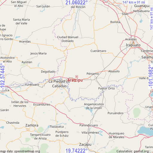
Aratzipu GPS coordinates[2]
20° 24' 9.468" North, 101° 52' 16.752" West
| Map corner | latitude | longitude |
|---|---|---|
| Upper-left | 21.06022°, | -102.57445° |
| Center: | 20.40263°, | -101.87132° |
| Lower-right: | 19.74222°, | -101.1682° |
| Map W x H: | 146.5×146.6 km | = 91×91.1mi |
| max Lat: | 32.7° ⇑34.3% North |
| Aratzipu: | 20.40263° |
| min Lat: | ⇓65.7% South 14.53588° |
| min Long | Aratzipu | max Long |
| -117.105° | -101.87132° | -86.73105° |
| W 19.8%⇐ | ⇒80.2% E |
Elevation
Elevation of Aratzipu is 1702 m = 5584 ft, and this is 448.3 m = 1471 ft above average elevation for this country.
| Max E: |
3497 m = 11473 ft | 41.4% |
| Aratzipu | 1702 m 5584 ft | |
| Avg. | 1253.7 m = 4113 ft | |
Min E: |
-1 m = -3 ft | 58.6% |
See also: Mexico elevation on elevation.city.
Geographical zone
Aratzipu is located in North Torrid zone (between Equator and Tropic of Cancer). Distance of this Northern Tropic circle is 337.4 km =209.7 mi to North.| Distance of | km | miles | from Aratzipu |
|---|---|---|---|
| North Pole | 7738.5 | 4808.5 | to North |
| Arctic Circle | 5132.6 | 3189.2 | to North |
| Tropic Cancer | 337.4 | 209.7 | to North |
| Equator | 2268.6 | 1409.6 | to South |


Nearby cities:
15 places around Aratzipu: (largest is in red/bold)
• Buenavista de Cortés
3.3 km =2.1 mi,  177°
177°
• Colonia Morelos
4.8 km =3 mi,  217°
217°
• Colorado de Herrera
9.7 km =6 mi,  162°
162°
• Corral de Santiago
7.8 km =4.8 mi, 182°
• La Cal Grande
10 km =6.2 mi,  229°
229°
• La Estrella
5.4 km =3.4 mi,  255°
255°
• La Madeja
8.7 km =5.4 mi,  296°
296°
• La Sarna
10.2 km =6.3 mi, 260°
• Laguna Larga de Cortés
7.3 km =4.5 mi, 261°
• Las Ánimas
7.5 km =4.7 mi,  94°
94°
• Los Ocotes
9.5 km =5.9 mi,  278°
278°
• Palo Alto de Abajo
7.7 km =4.8 mi,  120°
120°
• Palo Verde
9.1 km =5.7 mi,  165°
165°
• San Bernardo
5.8 km =3.6 mi,  151°
151°
• San Rafael de la Maraña
3.4 km =2.1 mi,  251°
251°
Sources, notices
• [Note1] Compared only with cities in Mexico existing in our database
• [Src1] Map data: © OpenStreetMap contributors (CC-BY-SA)
• [Src2] Other city data from geonames.org with taken over terms of usage.
• [Src3] Geographical zone / Annual Mean Temperature by Robert A. Rohde @ Wikipedia
