El Tejero geodata
El Tejero (Michoacán) is a populated place; located in Mexico in America/Mexico_City (GMT-6) time zone. With population of 606 people, there are 14202 cities with bigger population in this country. Compared to other cities in Mexico, 54.6% of cities are located further ↓South; 68.3% of cities are located further →East and 75.6% of cities have lower elevation than El Tejero. Note1


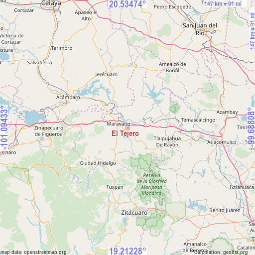
El Tejero GPS coordinates[2]
19° 52' 29.604" North, 100° 23' 28.32" West
| Map corner | latitude | longitude |
|---|---|---|
| Upper-left | 20.53474°, | -101.09433° |
| Center: | 19.87489°, | -100.3912° |
| Lower-right: | 19.21228°, | -99.68808° |
| Map W x H: | 147×147 km | = 91.3×91.3mi |
| max Lat: | 32.7° ⇑45.4% North |
| El Tejero: | 19.87489° |
| min Lat: | ⇓54.6% South 14.53588° |
| min Long | El Tejero | max Long |
| -117.105° | -100.3912° | -86.73105° |
| W 31.7%⇐ | ⇒68.3% E |
Elevation
Elevation of El Tejero is 2042 m = 6699 ft, and this is 788.3 m = 2586 ft above average elevation for this country.
| Max E: |
3497 m = 11473 ft | 24.4% |
| El Tejero | 2042 m 6699 ft | |
| Avg. | 1253.7 m = 4113 ft | |
Min E: |
-1 m = -3 ft | 75.6% |
See also: Mexico elevation on elevation.city.
Geographical zone
El Tejero is located in North Torrid zone (between Equator and Tropic of Cancer). Distance of this Northern Tropic circle is 396 km =246.1 mi to North.| Distance of | km | miles | from El Tejero |
|---|---|---|---|
| North Pole | 7797.2 | 4845 | to North |
| Arctic Circle | 5191.3 | 3225.7 | to North |
| Tropic Cancer | 396 | 246.1 | to North |
| Equator | 2209.9 | 1373.2 | to South |


Nearby cities:
15 places around El Tejero: (largest is in red/bold)
• Apeo
5.3 km =3.3 mi,  75°
75°
• Cachivi
8.4 km =5.2 mi,  155°
155°
• Campo Hermoso
3.8 km =2.4 mi,  202°
202°
• Casa Blanca
6 km =3.7 mi,  257°
257°
• Colonia Huandishi (Las Chinches)
5.5 km =3.4 mi,  42°
42°
• Colonia Yurécuaro
6.7 km =4.2 mi,  323°
323°
• Ejido de Pomas (Poblado de Dolores)
6.9 km =4.3 mi,  232°
232°
• José María Morelos
9.7 km =6 mi,  165°
165°
• Llano Grande
6.2 km =3.9 mi,  122°
122°
• Maravatío de Ocampo
5.9 km =3.7 mi,  287°
287°
• Pomoquita
2.9 km =1.8 mi,  61°
61°
• San Juan Huerta
9.2 km =5.7 mi,  190°
190°
• Santa Elena
2.5 km =1.6 mi,  224°
224°
• Tungareo
4.5 km =2.8 mi,  34°
34°
• Tupátaro
11.3 km =7 mi,  127°
127°
Sources, notices
• [Note1] Compared only with cities in Mexico existing in our database
• [Src1] Map data: © OpenStreetMap contributors (CC-BY-SA)
• [Src2] Other city data from geonames.org with taken over terms of usage.
• [Src3] Geographical zone / Annual Mean Temperature by Robert A. Rohde @ Wikipedia
