Tungareo geodata
Tungareo (Michoacán) is a populated place; located in Mexico in America/Mexico_City (GMT-6) time zone. With population of 4,597 people, there are 2002 cities with bigger population in this country. Compared to other cities in Mexico, 55.2% of cities are located further ↓South; 68.1% of cities are located further →East and 74.9% of cities have lower elevation than Tungareo. Note1


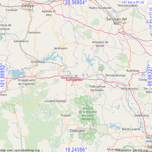
Tungareo GPS coordinates[2]
19° 54' 29.988" North, 100° 21' 59.004" West
| Map corner | latitude | longitude |
|---|---|---|
| Upper-left | 20.56804°, | -101.06952° |
| Center: | 19.90833°, | -100.36639° |
| Lower-right: | 19.24586°, | -99.66327° |
| Map W x H: | 147×147 km | = 91.3×91.3mi |
| max Lat: | 32.7° ⇑44.8% North |
| Tungareo: | 19.90833° |
| min Lat: | ⇓55.2% South 14.53588° |
| min Long | Tungareo | max Long |
| -117.105° | -100.36639° | -86.73105° |
| W 31.9%⇐ | ⇒68.1% E |
Elevation
Elevation of Tungareo is 2029 m = 6657 ft, and this is 775.3 m = 2544 ft above average elevation for this country.
| Max E: |
3497 m = 11473 ft | 25.1% |
| Tungareo | 2029 m 6657 ft | |
| Avg. | 1253.7 m = 4113 ft | |
Min E: |
-1 m = -3 ft | 74.9% |
See also: Mexico elevation on elevation.city.
Geographical zone
Tungareo is located in North Torrid zone (between Equator and Tropic of Cancer). Distance of this Northern Tropic circle is 392.3 km =243.8 mi to North.| Distance of | km | miles | from Tungareo |
|---|---|---|---|
| North Pole | 7793.5 | 4842.7 | to North |
| Arctic Circle | 5187.6 | 3223.4 | to North |
| Tropic Cancer | 392.3 | 243.8 | to North |
| Equator | 2213.6 | 1375.5 | to South |


Nearby cities:
15 places around Tungareo: (largest is in red/bold)
• Apeo
3.5 km =2.2 mi,  132°
132°
• Campo Hermoso
8.3 km =5.2 mi,  209°
209°
• Casa Blanca
9.8 km =6.1 mi,  239°
239°
• Colonia Huandishi (Las Chinches)
1.2 km =0.7 mi,  76°
76°
• Colonia Yurécuaro
6.8 km =4.2 mi,  283°
283°
• El Gigante
11.2 km =7 mi,  308°
308°
• El Tejero
4.5 km =2.8 mi, 214°
• La Higuerilla (Los Lirios)
9.5 km =5.9 mi, 80°
• La Huerta
10 km =6.2 mi,  116°
116°
• Llano Grande
7.5 km =4.7 mi,  159°
159°
• Maravatío de Ocampo
8.4 km =5.2 mi,  256°
256°
• Pomoquita
2.3 km =1.4 mi,  180°
180°
• San Ramón
11.3 km =7 mi,  94°
94°
• Santa Elena
7.1 km =4.4 mi,  218°
218°
• Tziritzícuaro
11.1 km =6.9 mi,  298°
298°
Sources, notices
• [Note1] Compared only with cities in Mexico existing in our database
• [Src1] Map data: © OpenStreetMap contributors (CC-BY-SA)
• [Src2] Other city data from geonames.org with taken over terms of usage.
• [Src3] Geographical zone / Annual Mean Temperature by Robert A. Rohde @ Wikipedia
