San Miguel del Monte geodata
San Miguel del Monte (Michoacán) is a populated place; located in Mexico in America/Mexico_City (GMT-6) time zone. With population of 892 people, there are 9779 cities with bigger population in this country. Compared to other cities in Mexico, 51.5% of cities are located further ↑North; 74.5% of cities are located further →East and 80.2% of cities have lower elevation than San Miguel del Monte. Note1
Current local time in San Miguel del Monte:
03:41 AM, WednesdayDifference from your time zone: hours


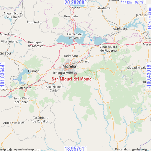
San Miguel del Monte GPS coordinates[2]
19° 37' 16.176" North, 101° 7' 59.916" West
| Map corner | latitude | longitude |
|---|---|---|
| Upper-left | 20.28208°, | -101.83644° |
| Center: | 19.62116°, | -101.13331° |
| Lower-right: | 18.95751°, | -100.43019° |
| Map W x H: | 147.3×147.3 km | = 91.5×91.5mi |
| max Lat: | 32.7° ⇑51.5% North |
| San Miguel del Monte: | 19.62116° |
| min Lat: | ⇓48.5% South 14.53588° |
| min Long | San Miguel del | max Long |
| -117.105° | -101.13331° | -86.73105° |
| W 25.5%⇐ | ⇒74.5% E |
Elevation
Elevation of San Miguel del Monte is 2145 m = 7037 ft, and this is 891.3 m = 2924 ft above average elevation for this country.
| Max E: |
3497 m = 11473 ft | 19.8% |
| San Miguel del Monte | 2145 m 7037 ft | |
| Avg. | 1253.7 m = 4113 ft | |
Min E: |
-1 m = -3 ft | 80.2% |
See also: Mexico elevation on elevation.city.
Geographical zone
San Miguel del Monte is located in North Torrid zone (between Equator and Tropic of Cancer). Distance of this Northern Tropic circle is 424.3 km =263.6 mi to North.| Distance of | km | miles | from San Miguel del Monte |
|---|---|---|---|
| North Pole | 7825.4 | 4862.5 | to North |
| Arctic Circle | 5219.5 | 3243.2 | to North |
| Tropic Cancer | 424.3 | 263.6 | to North |
| Equator | 2181.7 | 1355.6 | to South |


Nearby cities:
15 places around San Miguel del Monte: (largest is in red/bold)
• Atapaneo
13.2 km =8.2 mi,  7°
7°
• Cañadas del Bosque
12.5 km =7.8 mi,  18°
18°
• El Durazno
5.3 km =3.3 mi,  311°
311°
• Irapeo
11.2 km =7 mi,  44°
44°
• Jaripeo
8.3 km =5.2 mi, 37°
• Jesús del Monte
3.9 km =2.4 mi,  329°
329°
• Las Mesas
7 km =4.3 mi,  51°
51°
• Montaña Monarca (Punta Altozano)
5.5 km =3.4 mi,  322°
322°
• Morelia
10.3 km =6.4 mi, 328°
• Morelos
11.5 km =7.1 mi,  285°
285°
• Puerto de Buenavista (Lázaro Cárdenas)
7.5 km =4.7 mi,  4°
4°
• San José de las Torres
4.2 km =2.6 mi, 20°
• Tres Marías
9.3 km =5.8 mi, 11°
• Unión de Progreso (Lomas de Irapeo)
11 km =6.8 mi,  55°
55°
• Unión de Tabiqueros del Río Grande de Morelia
13.5 km =8.4 mi,  298°
298°
Sources, notices
• [Note1] Compared only with cities in Mexico existing in our database
• [Src1] Map data: © OpenStreetMap contributors (CC-BY-SA)
• [Src2] Other city data from geonames.org with taken over terms of usage.
• [Src3] Geographical zone / Annual Mean Temperature by Robert A. Rohde @ Wikipedia
