Morelos geodata
Morelos (Michoacán) is a populated place; located in Mexico in America/Mexico_City (GMT-6) time zone. With population of 13,565 people, there are 720 cities with bigger population in this country. Compared to other cities in Mexico, 50.9% of cities are located further ↑North; 75.2% of cities are located further →East and 71.2% of cities have lower elevation than Morelos. Note1


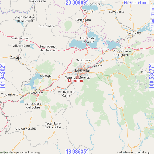
Morelos GPS coordinates[2]
19° 38' 56.004" North, 101° 14' 20.004" West
| Map corner | latitude | longitude |
|---|---|---|
| Upper-left | 20.30969°, | -101.94202° |
| Center: | 19.64889°, | -101.23889° |
| Lower-right: | 18.98535°, | -100.53577° |
| Map W x H: | 147.3×147.3 km | = 91.5×91.5mi |
| max Lat: | 32.7° ⇑50.9% North |
| Morelos: | 19.64889° |
| min Lat: | ⇓49.1% South 14.53588° |
| min Long | Morelos | max Long |
| -117.105° | -101.23889° | -86.73105° |
| W 24.8%⇐ | ⇒75.2% E |
Elevation
Elevation of Morelos is 1950 m = 6398 ft, and this is 696.3 m = 2284 ft above average elevation for this country.
| Max E: |
3497 m = 11473 ft | 28.8% |
| Morelos | 1950 m 6398 ft | |
| Avg. | 1253.7 m = 4113 ft | |
Min E: |
-1 m = -3 ft | 71.2% |
See also: Mexico elevation on elevation.city.
Geographical zone
Morelos is located in North Torrid zone (between Equator and Tropic of Cancer). Distance of this Northern Tropic circle is 421.2 km =261.7 mi to North.| Distance of | km | miles | from Morelos |
|---|---|---|---|
| North Pole | 7822.3 | 4860.6 | to North |
| Arctic Circle | 5216.4 | 3241.3 | to North |
| Tropic Cancer | 421.2 | 261.7 | to North |
| Equator | 2184.8 | 1357.6 | to South |


Nearby cities:
15 places around Morelos: (largest is in red/bold)
• Conjunto Habitacional Villas del Pedregal
7.8 km =4.8 mi,  299°
299°
• Coíntzio
2.6 km =1.6 mi,  250°
250°
• El Cerrito Itzícuaro
4.8 km =3 mi, 299°
• El Durazno
7.1 km =4.4 mi,  86°
86°
• Fraccionamiento San Lorenzo
5.2 km =3.2 mi,  313°
313°
• La Mintzita (Piedra Dura)
4.1 km =2.5 mi,  274°
274°
• Montaña Monarca (Punta Altozano)
7.8 km =4.8 mi,  80°
80°
• San Antonio
3.7 km =2.3 mi, 303°
• San Antonio Parangare
5.7 km =3.5 mi, 266°
• San Juanito Itzícuaro
3.4 km =2.1 mi,  331°
331°
• San Lorenzo Itzícuaro
5.4 km =3.4 mi, 305°
• Santiago Undameo
7.7 km =4.8 mi,  218°
218°
• Unión de Tabiqueros del Río Grande de Morelia
3.4 km =2.1 mi,  346°
346°
• Uruapilla
5.3 km =3.3 mi,  231°
231°
• Villas de la Loma
7.8 km =4.8 mi, 305°
Sources, notices
• [Note1] Compared only with cities in Mexico existing in our database
• [Src1] Map data: © OpenStreetMap contributors (CC-BY-SA)
• [Src2] Other city data from geonames.org with taken over terms of usage.
• [Src3] Geographical zone / Annual Mean Temperature by Robert A. Rohde @ Wikipedia
