Jesús del Monte geodata
Jesús del Monte (Michoacán) is a populated place; located in Mexico in America/Mexico_City (GMT-6) time zone. With population of 4,182 people, there are 2191 cities with bigger population in this country. Compared to other cities in Mexico, 50.9% of cities are located further ↑North; 74.6% of cities are located further →East and 80.5% of cities have lower elevation than Jesús del Monte. Note1


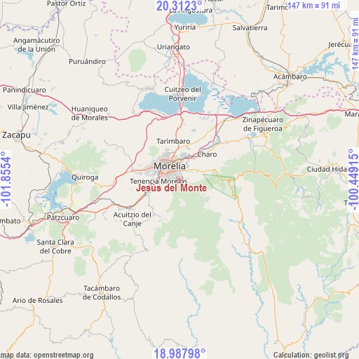
Jesús del Monte GPS coordinates[2]
19° 39' 5.436" North, 101° 9' 8.172" West
| Map corner | latitude | longitude |
|---|---|---|
| Upper-left | 20.3123°, | -101.8554° |
| Center: | 19.65151°, | -101.15227° |
| Lower-right: | 18.98798°, | -100.44915° |
| Map W x H: | 147.3×147.3 km | = 91.5×91.5mi |
| max Lat: | 32.7° ⇑50.9% North |
| Jesús del Monte: | 19.65151° |
| min Lat: | ⇓49.1% South 14.53588° |
| min Long | Jesús del Mont | max Long |
| -117.105° | -101.15227° | -86.73105° |
| W 25.4%⇐ | ⇒74.6% E |
Elevation
Elevation of Jesús del Monte is 2154 m = 7067 ft, and this is 900.3 m = 2954 ft above average elevation for this country.
| Max E: |
3497 m = 11473 ft | 19.5% |
| Jesús del Monte | 2154 m 7067 ft | |
| Avg. | 1253.7 m = 4113 ft | |
Min E: |
-1 m = -3 ft | 80.5% |
See also: Mexico elevation on elevation.city.
Geographical zone
Jesús del Monte is located in North Torrid zone (between Equator and Tropic of Cancer). Distance of this Northern Tropic circle is 420.9 km =261.5 mi to North.| Distance of | km | miles | from Jesús del Monte |
|---|---|---|---|
| North Pole | 7822 | 4860.4 | to North |
| Arctic Circle | 5216.1 | 3241.1 | to North |
| Tropic Cancer | 420.9 | 261.5 | to North |
| Equator | 2185 | 1357.7 | to South |


Nearby cities:
15 places around Jesús del Monte: (largest is in red/bold)
• Atapaneo
10.4 km =6.5 mi,  21°
21°
• Cañadas del Bosque
10.3 km =6.4 mi,  35°
35°
• El Durazno
2 km =1.2 mi,  275°
275°
• Irapeo
10.9 km =6.8 mi,  64°
64°
• Jaripeo
7.7 km =4.8 mi,  65°
65°
• La Aldea
10.3 km =6.4 mi,  10°
10°
• Las Mesas
7.5 km =4.7 mi,  82°
82°
• Montaña Monarca (Punta Altozano)
1.7 km =1.1 mi,  305°
305°
• Morelia
6.4 km =4 mi,  328°
328°
• Morelos
9.1 km =5.7 mi,  268°
268°
• Puerto de Buenavista (Lázaro Cárdenas)
4.8 km =3 mi,  32°
32°
• San José de las Torres
3.5 km =2.2 mi, 80°
• San Miguel del Monte
3.9 km =2.4 mi,  149°
149°
• Tres Marías
6.9 km =4.3 mi, 33°
• Unión de Tabiqueros del Río Grande de Morelia
10.3 km =6.4 mi,  287°
287°
Sources, notices
• [Note1] Compared only with cities in Mexico existing in our database
• [Src1] Map data: © OpenStreetMap contributors (CC-BY-SA)
• [Src2] Other city data from geonames.org with taken over terms of usage.
• [Src3] Geographical zone / Annual Mean Temperature by Robert A. Rohde @ Wikipedia
