La Palma geodata
La Palma (Michoacán) is a populated place; located in Mexico in America/Mexico_City (GMT-6) time zone. With population of 840 people, there are 10414 cities with bigger population in this country. Compared to other cities in Mexico, 56.3% of cities are located further ↑North; 68.2% of cities are located further →East and 61.4% of cities have lower elevation than La Palma. Note1


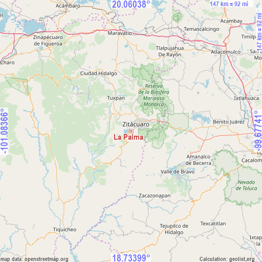
La Palma GPS coordinates[2]
19° 23' 54.744" North, 100° 22' 49.908" West
| Map corner | latitude | longitude |
|---|---|---|
| Upper-left | 20.06038°, | -101.08366° |
| Center: | 19.39854°, | -100.38053° |
| Lower-right: | 18.73399°, | -99.67741° |
| Map W x H: | 147.5×147.5 km | = 91.7×91.7mi |
| max Lat: | 32.7° ⇑56.3% North |
| La Palma: | 19.39854° |
| min Lat: | ⇓43.7% South 14.53588° |
| min Long | La Palma | max Long |
| -117.105° | -100.38053° | -86.73105° |
| W 31.8%⇐ | ⇒68.2% E |
Elevation
Elevation of La Palma is 1749 m = 5738 ft, and this is 495.3 m = 1625 ft above average elevation for this country.
| Max E: |
3497 m = 11473 ft | 38.6% |
| La Palma | 1749 m 5738 ft | |
| Avg. | 1253.7 m = 4113 ft | |
Min E: |
-1 m = -3 ft | 61.4% |
See also: Mexico elevation on elevation.city.
Geographical zone
La Palma is located in North Torrid zone (between Equator and Tropic of Cancer). Distance of this Northern Tropic circle is 449 km =279 mi to North.| Distance of | km | miles | from La Palma |
|---|---|---|---|
| North Pole | 7850.1 | 4877.8 | to North |
| Arctic Circle | 5244.3 | 3258.7 | to North |
| Tropic Cancer | 449 | 279 | to North |
| Equator | 2156.9 | 1340.2 | to South |


Nearby cities:
15 places around La Palma: (largest is in red/bold)
• Agua Salada
9.2 km =5.7 mi,  314°
314°
• Aputzio de Juárez
7.2 km =4.5 mi,  150°
150°
• Camémbaro
3.7 km =2.3 mi,  328°
328°
• Curungueo
8.3 km =5.2 mi,  27°
27°
• Enandio
8.9 km =5.5 mi,  215°
215°
• Heróica Zitácuaro
4.8 km =3 mi, 30°
• Ignacio López Rayón (Coyota Primera Manzana)
5.9 km =3.7 mi,  252°
252°
• La Encarnación
2 km =1.2 mi,  321°
321°
• La Joya de Manzanillo (Segunda Manzana)
9.5 km =5.9 mi,  59°
59°
• La Mesa (La Mesa de Cedano)
7.9 km =4.9 mi,  45°
45°
• Loma Larga
6.9 km =4.3 mi,  16°
16°
• Puerto Azul (Quinta Manzana de San Felipe)
9.2 km =5.7 mi,  348°
348°
• Rincón de Nicolás Romero (Cedros Tercera Manzana)
8.9 km =5.5 mi,  79°
79°
• Silva de Abajo
4 km =2.5 mi,  106°
106°
• Valle Verde
8.6 km =5.3 mi, 17°
Sources, notices
• [Note1] Compared only with cities in Mexico existing in our database
• [Src1] Map data: © OpenStreetMap contributors (CC-BY-SA)
• [Src2] Other city data from geonames.org with taken over terms of usage.
• [Src3] Geographical zone / Annual Mean Temperature by Robert A. Rohde @ Wikipedia
