Camémbaro geodata
Camémbaro (Michoacán) is a populated place; located in Mexico in America/Mexico_City (GMT-6) time zone. With population of 1,021 people, there are 8525 cities with bigger population in this country. Compared to other cities in Mexico, 55.6% of cities are located further ↑North; 68.4% of cities are located further →East and 60.8% of cities have lower elevation than Camémbaro. Note1


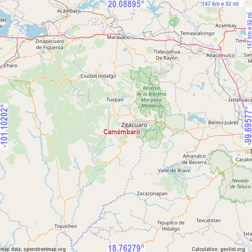
Camémbaro GPS coordinates[2]
19° 25' 37.992" North, 100° 23' 56.004" West
| Map corner | latitude | longitude |
|---|---|---|
| Upper-left | 20.08895°, | -101.10202° |
| Center: | 19.42722°, | -100.39889° |
| Lower-right: | 18.76279°, | -99.69577° |
| Map W x H: | 147.5×147.5 km | = 91.7×91.7mi |
| max Lat: | 32.7° ⇑55.6% North |
| Camémbaro: | 19.42722° |
| min Lat: | ⇓44.4% South 14.53588° |
| min Long | Camémbaro | max Long |
| -117.105° | -100.39889° | -86.73105° |
| W 31.6%⇐ | ⇒68.4% E |
Elevation
Elevation of Camémbaro is 1740 m = 5709 ft, and this is 486.3 m = 1595 ft above average elevation for this country.
| Max E: |
3497 m = 11473 ft | 39.2% |
| Camémbaro | 1740 m 5709 ft | |
| Avg. | 1253.7 m = 4113 ft | |
Min E: |
-1 m = -3 ft | 60.8% |
See also: Mexico elevation on elevation.city.
Geographical zone
Camémbaro is located in North Torrid zone (between Equator and Tropic of Cancer). Distance of this Northern Tropic circle is 445.8 km =277 mi to North.| Distance of | km | miles | from Camémbaro |
|---|---|---|---|
| North Pole | 7847 | 4875.9 | to North |
| Arctic Circle | 5241.1 | 3256.7 | to North |
| Tropic Cancer | 445.8 | 277 | to North |
| Equator | 2160.1 | 1342.2 | to South |


Nearby cities:
15 places around Camémbaro: (largest is in red/bold)
• Agua Salada
5.7 km =3.5 mi,  305°
305°
• Curungueo
7.1 km =4.4 mi,  54°
54°
• El Mango
7.7 km =4.8 mi,  315°
315°
• Heróica Zitácuaro
4.5 km =2.8 mi,  77°
77°
• Ignacio López Rayón (Coyota Primera Manzana)
6.2 km =3.9 mi,  216°
216°
• La Encarnación
1.8 km =1.1 mi,  156°
156°
• La Mesa (La Mesa de Cedano)
7.9 km =4.9 mi,  72°
72°
• La Palma
3.7 km =2.3 mi,  148°
148°
• Loma Larga
5.2 km =3.2 mi, 49°
• Mesa de los Alzati (Mesa de San Felipe)
8.1 km =5 mi,  7°
7°
• Ocurio
6.7 km =4.2 mi,  337°
337°
• Puerto Azul (Quinta Manzana de San Felipe)
5.8 km =3.6 mi,  1°
1°
• San Felipe los Alzati (Colonia Nueva)
7.4 km =4.6 mi,  20°
20°
• Silva de Abajo
7.2 km =4.5 mi,  126°
126°
• Valle Verde
6.8 km =4.2 mi,  42°
42°
Sources, notices
• [Note1] Compared only with cities in Mexico existing in our database
• [Src1] Map data: © OpenStreetMap contributors (CC-BY-SA)
• [Src2] Other city data from geonames.org with taken over terms of usage.
• [Src3] Geographical zone / Annual Mean Temperature by Robert A. Rohde @ Wikipedia
