Valle Verde geodata
Valle Verde (Michoacán) is a populated place; located in Mexico in America/Mexico_City (GMT-6) time zone. With population of 1,617 people, there are 5355 cities with bigger population in this country. Compared to other cities in Mexico, 54.7% of cities are located further ↑North; 68% of cities are located further →East and 69.6% of cities have lower elevation than Valle Verde. Note1


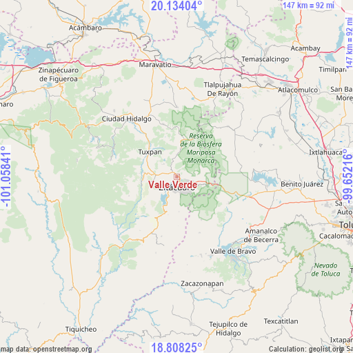
Valle Verde GPS coordinates[2]
19° 28' 21" North, 100° 21' 19.008" West
| Map corner | latitude | longitude |
|---|---|---|
| Upper-left | 20.13404°, | -101.05841° |
| Center: | 19.4725°, | -100.35528° |
| Lower-right: | 18.80825°, | -99.65216° |
| Map W x H: | 147.4×147.4 km | = 91.6×91.6mi |
| max Lat: | 32.7° ⇑54.7% North |
| Valle Verde: | 19.4725° |
| min Lat: | ⇓45.3% South 14.53588° |
| min Long | Valle Verde | max Long |
| -117.105° | -100.35528° | -86.73105° |
| W 32%⇐ | ⇒68% E |
Elevation
Elevation of Valle Verde is 1917 m = 6289 ft, and this is 663.3 m = 2176 ft above average elevation for this country.
| Max E: |
3497 m = 11473 ft | 30.4% |
| Valle Verde | 1917 m 6289 ft | |
| Avg. | 1253.7 m = 4113 ft | |
Min E: |
-1 m = -3 ft | 69.6% |
See also: Mexico elevation on elevation.city.
Geographical zone
Valle Verde is located in North Torrid zone (between Equator and Tropic of Cancer). Distance of this Northern Tropic circle is 440.8 km =273.9 mi to North.| Distance of | km | miles | from Valle Verde |
|---|---|---|---|
| North Pole | 7841.9 | 4872.7 | to North |
| Arctic Circle | 5236 | 3253.5 | to North |
| Tropic Cancer | 440.8 | 273.9 | to North |
| Equator | 2165.1 | 1345.3 | to South |


Nearby cities:
15 places around Valle Verde: (largest is in red/bold)
• Carpinteros
4.5 km =2.8 mi,  64°
64°
• Chimusdá (Cuarta Manzana de Donaciano Ojeda)
5.9 km =3.7 mi,  89°
89°
• Colonia Emiliano Zapata (San Juan Zitácuaro)
5.9 km =3.7 mi,  117°
117°
• Curungueo
1.5 km =0.9 mi,  125°
125°
• El Rincón de San Felipe (Tercera Manzana San Felipe)
4.2 km =2.6 mi,  334°
334°
• Heróica Zitácuaro
4.1 km =2.5 mi,  183°
183°
• La Fundición (Quinta Manzana)
5.7 km =3.5 mi,  109°
109°
• La Mesa (La Mesa de Cedano)
4 km =2.5 mi, 132°
• Loma Larga
1.8 km =1.1 mi,  201°
201°
• Macutzio
3 km =1.9 mi,  0°
0°
• Mesa de los Alzati (Mesa de San Felipe)
4.6 km =2.9 mi,  309°
309°
• Puentecillas (Tercera Manzana de Zirahuato)
6.3 km =3.9 mi,  304°
304°
• Puerto Azul (Quinta Manzana de San Felipe)
4.5 km =2.8 mi,  279°
279°
• Rincón de Curungueo
1.7 km =1.1 mi,  44°
44°
• San Felipe los Alzati (Colonia Nueva)
2.7 km =1.7 mi, 314°
Sources, notices
• [Note1] Compared only with cities in Mexico existing in our database
• [Src1] Map data: © OpenStreetMap contributors (CC-BY-SA)
• [Src2] Other city data from geonames.org with taken over terms of usage.
• [Src3] Geographical zone / Annual Mean Temperature by Robert A. Rohde @ Wikipedia
