Parícuaro geodata
Parícuaro (Michoacán) is a populated place; located in Mexico in America/Mexico_City (GMT-6) time zone. With population of 2,284 people, there are 3855 cities with bigger population in this country. Compared to other cities in Mexico, 59.6% of cities are located further ↑North; 69.1% of cities are located further →East and 53.2% of cities have higher elevation than Parícuaro. Note1


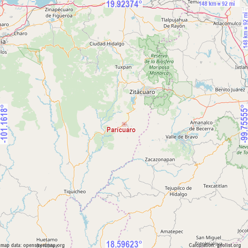
Parícuaro GPS coordinates[2]
19° 15' 40.788" North, 100° 27' 31.212" West
| Map corner | latitude | longitude |
|---|---|---|
| Upper-left | 19.92374°, | -101.1618° |
| Center: | 19.26133°, | -100.45867° |
| Lower-right: | 18.59623°, | -99.75555° |
| Map W x H: | 147.6×147.6 km | = 91.7×91.7mi |
| max Lat: | 32.7° ⇑59.6% North |
| Parícuaro: | 19.26133° |
| min Lat: | ⇓40.4% South 14.53588° |
| min Long | Parícuaro | max Long |
| -117.105° | -100.45867° | -86.73105° |
| W 30.9%⇐ | ⇒69.1% E |
Elevation
Elevation of Parícuaro is 1280 m = 4199 ft, and this is 26.3 m = 86 ft above average elevation for this country.
| Max E: |
3497 m = 11473 ft | 53.2% |
| Parícuaro | 1280 m 4199 ft | |
| Avg. | 1253.7 m = 4113 ft | |
Min E: |
-1 m = -3 ft | 46.8% |
See also: Mexico elevation on elevation.city.
Geographical zone
Parícuaro is located in North Torrid zone (between Equator and Tropic of Cancer). Distance of this Northern Tropic circle is 464.3 km =288.5 mi to North.| Distance of | km | miles | from Parícuaro |
|---|---|---|---|
| North Pole | 7865.4 | 4887.3 | to North |
| Arctic Circle | 5259.5 | 3268.1 | to North |
| Tropic Cancer | 464.3 | 288.5 | to North |
| Equator | 2141.7 | 1330.8 | to South |


Nearby cities:
15 places around Parícuaro: (largest is in red/bold)
• Arroyo Seco
14.7 km =9.1 mi,  243°
243°
• Benito Juárez
3.2 km =2 mi,  195°
195°
• Benito Juárez
6.4 km =4 mi,  24°
24°
• Cerro Colorado de Ocampo
6.2 km =3.9 mi,  353°
353°
• Dolores (Ex-Hacienda de Dolores)
12.1 km =7.5 mi,  100°
100°
• El Rodeo
5.1 km =3.2 mi, 346°
• Enandio
8.6 km =5.3 mi, 20°
• Ignacio López Rayón (Coyota Primera Manzana)
13.7 km =8.5 mi,  10°
10°
• La Florida
11.7 km =7.3 mi,  336°
336°
• Manzana de la Mora
9.6 km =6 mi,  324°
324°
• Rancho Viejo
4.6 km =2.9 mi,  107°
107°
• Santa Ana de Guerrero (El Cascabel)
2.5 km =1.6 mi,  47°
47°
• Susupuato de Guerrero
7.4 km =4.6 mi,  134°
134°
• Tremesino
8.4 km =5.2 mi,  166°
166°
• Tuzantla
13.1 km =8.1 mi, 240°
Sources, notices
• [Note1] Compared only with cities in Mexico existing in our database
• [Src1] Map data: © OpenStreetMap contributors (CC-BY-SA)
• [Src2] Other city data from geonames.org with taken over terms of usage.
• [Src3] Geographical zone / Annual Mean Temperature by Robert A. Rohde @ Wikipedia
