Benito Juárez geodata
Benito Juárez (Michoacán) is a seat of a second-order administrative division; located in Mexico in America/Mexico_City (GMT-6) time zone. With population of 3,639 people, there are 2518 cities with bigger population in this country. Compared to other cities in Mexico, 58.6% of cities are located further ↑North; 68.8% of cities are located further →East and 52.3% of cities have higher elevation than Benito Juárez. Note1


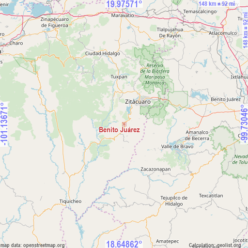
Benito Juárez GPS coordinates[2]
19° 18' 48.636" North, 100° 26' 0.888" West
| Map corner | latitude | longitude |
|---|---|---|
| Upper-left | 19.97571°, | -101.13671° |
| Center: | 19.31351°, | -100.43358° |
| Lower-right: | 18.64862°, | -99.73046° |
| Map W x H: | 147.6×147.6 km | = 91.7×91.7mi |
| max Lat: | 32.7° ⇑58.6% North |
| Benito Juárez: | 19.31351° |
| min Lat: | ⇓41.4% South 14.53588° |
| min Long | Benito Juárez | max Long |
| -117.105° | -100.43358° | -86.73105° |
| W 31.2%⇐ | ⇒68.8% E |
Elevation
Elevation of Benito Juárez is 1325 m = 4347 ft, and this is 71.3 m = 234 ft above average elevation for this country.
| Max E: |
3497 m = 11473 ft | 52.3% |
| Benito Juárez | 1325 m 4347 ft | |
| Avg. | 1253.7 m = 4113 ft | |
Min E: |
-1 m = -3 ft | 47.7% |
See also: Mexico elevation on elevation.city.
Geographical zone
Benito Juárez is located in North Torrid zone (between Equator and Tropic of Cancer). Distance of this Northern Tropic circle is 458.5 km =284.9 mi to North.| Distance of | km | miles | from Benito Juárez |
|---|---|---|---|
| North Pole | 7859.6 | 4883.7 | to North |
| Arctic Circle | 5253.7 | 3264.5 | to North |
| Tropic Cancer | 458.5 | 284.9 | to North |
| Equator | 2147.5 | 1334.4 | to South |


Nearby cities:
15 places around Benito Juárez: (largest is in red/bold)
• Aputzio de Juárez
9.6 km =6 mi,  70°
70°
• Benito Juárez
9.6 km =6 mi,  201°
201°
• Cerro Colorado de Ocampo
3.4 km =2.1 mi,  276°
276°
• El Rodeo
3.9 km =2.4 mi,  257°
257°
• Enandio
2.2 km =1.4 mi,  9°
9°
• Huanguitío
10.9 km =6.8 mi,  328°
328°
• Ignacio López Rayón (Coyota Primera Manzana)
7.7 km =4.8 mi,  359°
359°
• La Encarnación
11.8 km =7.3 mi,  21°
21°
• La Florida
8.8 km =5.5 mi,  303°
303°
• La Palma
11 km =6.8 mi,  30°
30°
• Manzana de la Mora
8.5 km =5.3 mi, 283°
• Parícuaro
6.4 km =4 mi, 204°
• Rancho Viejo
7.4 km =4.6 mi,  166°
166°
• Santa Ana de Guerrero (El Cascabel)
4.2 km =2.6 mi,  191°
191°
• Susupuato de Guerrero
11.3 km =7 mi, 166°
Sources, notices
• [Note1] Compared only with cities in Mexico existing in our database
• [Src1] Map data: © OpenStreetMap contributors (CC-BY-SA)
• [Src2] Other city data from geonames.org with taken over terms of usage.
• [Src3] Geographical zone / Annual Mean Temperature by Robert A. Rohde @ Wikipedia
