San Nicolás Arroyo Hondo geodata
San Nicolás Arroyo Hondo (Michoacán) is a populated place; located in Mexico in America/Mexico_City (GMT-6) time zone. With population of 509 people, there are 16517 cities with bigger population in this country. Compared to other cities in Mexico, 72.1% of cities are located further ↑North; 72.3% of cities are located further →East and 74.4% of cities have higher elevation than San Nicolás Arroyo Hondo. Note1
Current local time in San Nicolás Arroyo Hondo:
10:23 AM, MondayDifference from your time zone: hours


San Nicolás Arroyo Hondo GPS coordinates[2]
18° 32' 14.064" North, 100° 51' 39.276" West
| Map corner | latitude | longitude |
|---|---|---|
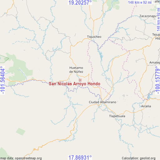
| Upper-left | 19.20257°, | -101.56404° |
| Center: | 18.53724°, | -100.86091° |
| Lower-right: | 17.86931°, | -100.15779° |
| Map W x H: | 148.2×148.2 km | = 92.1×92.1mi |
| max Lat: | 32.7° ⇑72.1% North |
| San Nicolás Arroyo Hondo: | 18.53724° |
| min Lat: | ⇓27.9% South 14.53588° |
| min Long | San Nicolás Ar | max Long |
| -117.105° | -100.86091° | -86.73105° |
| W 27.7%⇐ | ⇒72.3% E |
Elevation
Elevation of San Nicolás Arroyo Hondo is 238 m = 781 ft, and this is 1015.7 m = 3332 ft below average elevation for this country.
| Max E: |
3497 m = 11473 ft | 74.4% |
| Avg. | 1253.7 m = 4113 ft | |
| San Nicolás Arroyo Hondo | 238 m = 781 ft | |
Min E: |
-1 m = -3 ft | 25.6% |
See also: Mexico elevation on elevation.city.
Geographical zone
San Nicolás Arroyo Hondo is located in North Torrid zone (between Equator and Tropic of Cancer). Distance of this Northern Tropic circle is 544.8 km =338.5 mi to North.| Distance of | km | miles | from San Nicolás Arroyo Hondo |
|---|---|---|---|
| North Pole | 7945.9 | 4937.4 | to North |
| Arctic Circle | 5340 | 3318.1 | to North |
| Tropic Cancer | 544.8 | 338.5 | to North |
| Equator | 2061.1 | 1280.7 | to South |


Nearby cities:
15 places around San Nicolás Arroyo Hondo: (largest is in red/bold)
• Angao
17.5 km =10.9 mi,  26°
26°
• Capeo
18.8 km =11.7 mi,  267°
267°
• Comburindio
11.5 km =7.1 mi,  276°
276°
• El Naranjo
20.1 km =12.5 mi,  187°
187°
• Huetamo de Núñez
10.9 km =6.8 mi,  339°
339°
• La Calera
19.7 km =12.2 mi,  230°
230°
• La Parota
14.6 km =9.1 mi,  348°
348°
• Purechucho
5.8 km =3.6 mi,  329°
329°
• San Lucas
9.9 km =6.2 mi,  53°
53°
• Santa Teresa
22.1 km =13.7 mi,  169°
169°
• Santo Domingo
20.5 km =12.7 mi,  137°
137°
• Tamácuaro
22.5 km =14 mi,  101°
101°
• Turitzio
9.1 km =5.7 mi,  262°
262°
• Tziritzícuaro
4.6 km =2.9 mi,  178°
178°
• Zirándaro de los Chávez
14.2 km =8.8 mi,  241°
241°
Sources, notices
• [Note1] Compared only with cities in Mexico existing in our database
• [Src1] Map data: © OpenStreetMap contributors (CC-BY-SA)
• [Src2] Other city data from geonames.org with taken over terms of usage.
• [Src3] Geographical zone / Annual Mean Temperature by Robert A. Rohde @ Wikipedia
