Huetamo de Núñez geodata
Huetamo de Núñez (Michoacán) is a seat of a second-order administrative division; located in Mexico in America/Mexico_City (GMT-6) time zone. With population of 21,864 people, there are 469 cities with bigger population in this country. Compared to other cities in Mexico, 71% of cities are located further ↑North; 72.6% of cities are located further →East and 72.7% of cities have higher elevation than Huetamo de Núñez. Note1


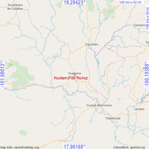
Huetamo de Núñez GPS coordinates[2]
18° 37' 45.336" North, 100° 53' 49.2" West
| Map corner | latitude | longitude |
|---|---|---|
| Upper-left | 19.29423°, | -101.60013° |
| Center: | 18.62926°, | -100.897° |
| Lower-right: | 17.96168°, | -100.19388° |
| Map W x H: | 148.2×148.2 km | = 92.1×92.1mi |
| max Lat: | 32.7° ⇑71% North |
| Huetamo de Núñez: | 18.62926° |
| min Lat: | ⇓29% South 14.53588° |
| min Long | Huetamo de Nú� | max Long |
| -117.105° | -100.897° | -86.73105° |
| W 27.4%⇐ | ⇒72.6% E |
Elevation
Elevation of Huetamo de Núñez is 304 m = 997 ft, and this is 949.7 m = 3116 ft below average elevation for this country.
| Max E: |
3497 m = 11473 ft | 72.7% |
| Avg. | 1253.7 m = 4113 ft | |
| Huetamo de Núñez | 304 m = 997 ft | |
Min E: |
-1 m = -3 ft | 27.3% |
See also: Mexico elevation on elevation.city.
Geographical zone
Huetamo de Núñez is located in North Torrid zone (between Equator and Tropic of Cancer). Distance of this Northern Tropic circle is 534.5 km =332.1 mi to North.| Distance of | km | miles | from Huetamo de Núñez |
|---|---|---|---|
| North Pole | 7935.7 | 4931 | to North |
| Arctic Circle | 5329.8 | 3311.8 | to North |
| Tropic Cancer | 534.5 | 332.1 | to North |
| Equator | 2071.4 | 1287.1 | to South |


Nearby cities:
15 places around Huetamo de Núñez: (largest is in red/bold)
• Angao
12.9 km =8 mi,  65°
65°
• Arroyo Grande
22.4 km =13.9 mi,  75°
75°
• Capeo
18.6 km =11.6 mi,  233°
233°
• Comburindio
11.8 km =7.3 mi,  220°
220°
• La Calera
25.5 km =15.8 mi,  206°
206°
• La Parota
4.2 km =2.6 mi,  14°
14°
• Nuevo Galeana
29.8 km =18.5 mi,  108°
108°
• Paso de Núñez (Buenavista)
30 km =18.6 mi,  349°
349°
• Purechucho
5.3 km =3.3 mi,  170°
170°
• San Lucas
12.5 km =7.8 mi, 110°
• San Nicolás Arroyo Hondo
10.9 km =6.8 mi,  159°
159°
• Tamácuaro
29.8 km =18.5 mi,  119°
119°
• Turitzio
12.5 km =7.8 mi,  204°
204°
• Tziritzícuaro
15.4 km =9.6 mi, 165°
• Zirándaro de los Chávez
19.1 km =11.9 mi, 206°
Sources, notices
• [Note1] Compared only with cities in Mexico existing in our database
• [Src1] Map data: © OpenStreetMap contributors (CC-BY-SA)
• [Src2] Other city data from geonames.org with taken over terms of usage.
• [Src3] Geographical zone / Annual Mean Temperature by Robert A. Rohde @ Wikipedia
