San Lucas geodata
San Lucas (Michoacán) is a seat of a second-order administrative division; located in Mexico in America/Mexico_City (GMT-6) time zone. With population of 3,085 people, there are 2919 cities with bigger population in this country. Compared to other cities in Mexico, 71.6% of cities are located further ↑North; 71.7% of cities are located further →East and 72.5% of cities have higher elevation than San Lucas. Note1


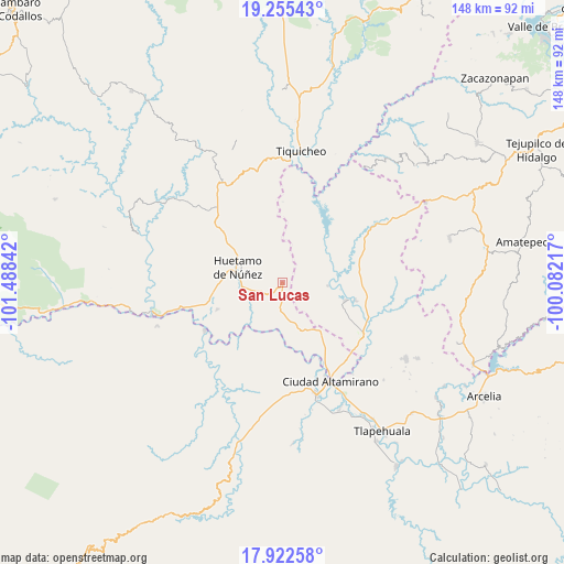
San Lucas GPS coordinates[2]
18° 35' 25.116" North, 100° 47' 7.044" West
| Map corner | latitude | longitude |
|---|---|---|
| Upper-left | 19.25543°, | -101.48842° |
| Center: | 18.59031°, | -100.78529° |
| Lower-right: | 17.92258°, | -100.08217° |
| Map W x H: | 148.2×148.2 km | = 92.1×92.1mi |
| max Lat: | 32.7° ⇑71.6% North |
| San Lucas: | 18.59031° |
| min Lat: | ⇓28.4% South 14.53588° |
| min Long | San Lucas | max Long |
| -117.105° | -100.78529° | -86.73105° |
| W 28.3%⇐ | ⇒71.7% E |
Elevation
Elevation of San Lucas is 311 m = 1020 ft, and this is 942.7 m = 3093 ft below average elevation for this country.
| Max E: |
3497 m = 11473 ft | 72.5% |
| Avg. | 1253.7 m = 4113 ft | |
| San Lucas | 311 m = 1020 ft | |
Min E: |
-1 m = -3 ft | 27.5% |
See also: Mexico elevation on elevation.city.
Geographical zone
San Lucas is located in North Torrid zone (between Equator and Tropic of Cancer). Distance of this Northern Tropic circle is 538.9 km =334.9 mi to North.| Distance of | km | miles | from San Lucas |
|---|---|---|---|
| North Pole | 7940 | 4933.7 | to North |
| Arctic Circle | 5334.1 | 3314.5 | to North |
| Tropic Cancer | 538.9 | 334.9 | to North |
| Equator | 2067 | 1284.4 | to South |


Nearby cities:
15 places around San Lucas: (largest is in red/bold)
• Angao
9.7 km =6 mi,  359°
359°
• Arroyo Grande
14 km =8.7 mi,  45°
45°
• Comburindio
20 km =12.4 mi,  256°
256°
• El Salitre (Sirapitiro)
21.4 km =13.3 mi,  88°
88°
• Huetamo de Núñez
12.5 km =7.8 mi,  290°
290°
• La Parota
13.6 km =8.5 mi,  307°
307°
• Nuevo Galeana
17.3 km =10.7 mi,  106°
106°
• Purechucho
10.9 km =6.8 mi,  265°
265°
• San Nicolás Arroyo Hondo
9.9 km =6.2 mi,  233°
233°
• Santo Domingo
21.8 km =13.5 mi,  164°
164°
• Tacupa
23 km =14.3 mi,  151°
151°
• Tamácuaro
17.6 km =10.9 mi,  126°
126°
• Turitzio
18.4 km =11.4 mi,  247°
247°
• Tziritzícuaro
13.1 km =8.1 mi,  216°
216°
• Zacapuato
20.8 km =12.9 mi,  65°
65°
Sources, notices
• [Note1] Compared only with cities in Mexico existing in our database
• [Src1] Map data: © OpenStreetMap contributors (CC-BY-SA)
• [Src2] Other city data from geonames.org with taken over terms of usage.
• [Src3] Geographical zone / Annual Mean Temperature by Robert A. Rohde @ Wikipedia
