El Guaco geodata
El Guaco (Michoacán) is a populated place; located in Mexico in America/Mexico_City (GMT-6) time zone. With population of 1,194 people, there are 7274 cities with bigger population in this country. Compared to other cities in Mexico, 63.6% of cities are located further ↑North; 81.3% of cities are located further →East and 69.2% of cities have higher elevation than El Guaco. Note1


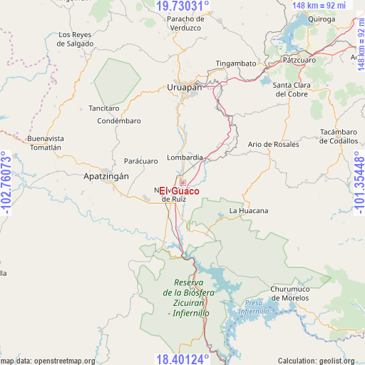
El Guaco GPS coordinates[2]
19° 4' 1.596" North, 102° 3' 27.36" West
| Map corner | latitude | longitude |
|---|---|---|
| Upper-left | 19.73031°, | -102.76073° |
| Center: | 19.06711°, | -102.0576° |
| Lower-right: | 18.40124°, | -101.35448° |
| Map W x H: | 147.8×147.8 km | = 91.8×91.8mi |
| max Lat: | 32.7° ⇑63.6% North |
| El Guaco: | 19.06711° |
| min Lat: | ⇓36.4% South 14.53588° |
| min Long | El Guaco | max Long |
| -117.105° | -102.0576° | -86.73105° |
| W 18.7%⇐ | ⇒81.3% E |
Elevation
Elevation of El Guaco is 458 m = 1503 ft, and this is 795.7 m = 2611 ft below average elevation for this country.
| Max E: |
3497 m = 11473 ft | 69.2% |
| Avg. | 1253.7 m = 4113 ft | |
| El Guaco | 458 m = 1503 ft | |
Min E: |
-1 m = -3 ft | 30.8% |
See also: Mexico elevation on elevation.city.
Geographical zone
El Guaco is located in North Torrid zone (between Equator and Tropic of Cancer). Distance of this Northern Tropic circle is 485.9 km =301.9 mi to North.| Distance of | km | miles | from El Guaco |
|---|---|---|---|
| North Pole | 7887 | 4900.8 | to North |
| Arctic Circle | 5281.1 | 3281.5 | to North |
| Tropic Cancer | 485.9 | 301.9 | to North |
| Equator | 2120.1 | 1317.4 | to South |


Nearby cities:
15 places around El Guaco: (largest is in red/bold)
• Antúnez
16.5 km =10.3 mi,  249°
249°
• Antúnez (Morelos)
16.5 km =10.3 mi, 248°
• Buenos Aires
12.9 km =8 mi,  273°
273°
• Cuatro Caminos
10 km =6.2 mi,  208°
208°
• El Caulote
10.1 km =6.3 mi,  309°
309°
• El Ceñidor
15.7 km =9.8 mi,  242°
242°
• El Chauz
19.6 km =12.2 mi,  174°
174°
• El Letrero
12.8 km =8 mi, 205°
• Estación Nueva Italia
3 km =1.9 mi, 268°
• Gambara
16.1 km =10 mi,  201°
201°
• La Ibérica (La Gotera)
18.4 km =11.4 mi,  53°
53°
• Lombardía
10.1 km =6.3 mi,  3°
3°
• Nueva Italia de Ruiz
6 km =3.7 mi,  218°
218°
• Paracuaro
19.2 km =11.9 mi,  298°
298°
• Santa Casilda
14.5 km =9 mi, 48°
Sources, notices
• [Note1] Compared only with cities in Mexico existing in our database
• [Src1] Map data: © OpenStreetMap contributors (CC-BY-SA)
• [Src2] Other city data from geonames.org with taken over terms of usage.
• [Src3] Geographical zone / Annual Mean Temperature by Robert A. Rohde @ Wikipedia
