Trojes geodata
Trojes (State of Mexico) is a populated place; located in Mexico in America/Mexico_City (GMT-6) time zone. With population of 948 people, there are 9188 cities with bigger population in this country. Compared to other cities in Mexico, 66.3% of cities are located further ↑North; 67.1% of cities are located further →East and 56.8% of cities have higher elevation than Trojes. Note1


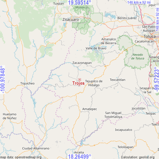
Trojes GPS coordinates[2]
18° 55' 53.004" North, 100° 16' 31.26" West
| Map corner | latitude | longitude |
|---|---|---|
| Upper-left | 19.59514°, | -100.97848° |
| Center: | 18.93139°, | -100.27535° |
| Lower-right: | 18.26499°, | -99.57223° |
| Map W x H: | 147.9×147.9 km | = 91.9×91.9mi |
| max Lat: | 32.7° ⇑66.3% North |
| Trojes: | 18.93139° |
| min Lat: | ⇓33.7% South 14.53588° |
| min Long | Trojes | max Long |
| -117.105° | -100.27535° | -86.73105° |
| W 32.9%⇐ | ⇒67.1% E |
Elevation
Elevation of Trojes is 1127 m = 3698 ft, and this is 126.7 m = 416 ft below average elevation for this country.
| Max E: |
3497 m = 11473 ft | 56.8% |
| Avg. | 1253.7 m = 4113 ft | |
| Trojes | 1127 m = 3698 ft | |
Min E: |
-1 m = -3 ft | 43.2% |
See also: Mexico elevation on elevation.city.
Geographical zone
Trojes is located in North Torrid zone (between Equator and Tropic of Cancer). Distance of this Northern Tropic circle is 500.9 km =311.2 mi to North.| Distance of | km | miles | from Trojes |
|---|---|---|---|
| North Pole | 7902.1 | 4910.1 | to North |
| Arctic Circle | 5296.2 | 3290.9 | to North |
| Tropic Cancer | 500.9 | 311.2 | to North |
| Equator | 2105 | 1308 | to South |


Nearby cities:
15 places around Trojes: (largest is in red/bold)
• Caja de Agua
3.9 km =2.4 mi,  328°
328°
• Colonia Buenavista Primera Sección
12.6 km =7.8 mi,  98°
98°
• El Estanco
3.9 km =2.4 mi,  150°
150°
• Hermiltepec
12.1 km =7.5 mi,  303°
303°
• Jalpan (Jalpan San Simón)
11.7 km =7.3 mi,  92°
92°
• La Finca
12.2 km =7.6 mi,  34°
34°
• Rincón de Jaimes
12.1 km =7.5 mi,  107°
107°
• Rincón de Ugarte
13.1 km =8.1 mi, 91°
• San José de la Laguna
11.1 km =6.9 mi,  81°
81°
• San Juan Acatitlán
8.9 km =5.5 mi,  350°
350°
• Sauz de San Lucas (El Sauz)
8.8 km =5.5 mi, 32°
• Suquitila
8.9 km =5.5 mi, 81°
• Tejupilco de Hidalgo
13.2 km =8.2 mi, 102°
• Villa Luvianos
2.7 km =1.7 mi,  242°
242°
• Villa Luvianos
13.2 km =8.2 mi,  262°
262°
Sources, notices
• [Note1] Compared only with cities in Mexico existing in our database
• [Src1] Map data: © OpenStreetMap contributors (CC-BY-SA)
• [Src2] Other city data from geonames.org with taken over terms of usage.
• [Src3] Geographical zone / Annual Mean Temperature by Robert A. Rohde @ Wikipedia
