La Finca geodata
La Finca (State of Mexico) is a populated place; located in Mexico in America/Mexico_City (GMT-6) time zone. With population of 666 people, there are 13039 cities with bigger population in this country. Compared to other cities in Mexico, 64.3% of cities are located further ↑North; 66.5% of cities are located further →East and 50.5% of cities have lower elevation than La Finca. Note1


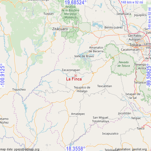
La Finca GPS coordinates[2]
19° 1' 18.66" North, 100° 12' 33.732" West
| Map corner | latitude | longitude |
|---|---|---|
| Upper-left | 19.68524°, | -100.9125° |
| Center: | 19.02185°, | -100.20937° |
| Lower-right: | 18.3558°, | -99.50625° |
| Map W x H: | 147.8×147.8 km | = 91.8×91.8mi |
| max Lat: | 32.7° ⇑64.3% North |
| La Finca: | 19.02185° |
| min Lat: | ⇓35.7% South 14.53588° |
| min Long | La Finca | max Long |
| -117.105° | -100.20937° | -86.73105° |
| W 33.5%⇐ | ⇒66.5% E |
Elevation
Elevation of La Finca is 1455 m = 4774 ft, and this is 201.3 m = 660 ft above average elevation for this country.
| Max E: |
3497 m = 11473 ft | 49.5% |
| La Finca | 1455 m 4774 ft | |
| Avg. | 1253.7 m = 4113 ft | |
Min E: |
-1 m = -3 ft | 50.5% |
See also: Mexico elevation on elevation.city.
Geographical zone
La Finca is located in North Torrid zone (between Equator and Tropic of Cancer). Distance of this Northern Tropic circle is 490.9 km =305 mi to North.| Distance of | km | miles | from La Finca |
|---|---|---|---|
| North Pole | 7892 | 4903.9 | to North |
| Arctic Circle | 5286.1 | 3284.6 | to North |
| Tropic Cancer | 490.9 | 305 | to North |
| Equator | 2115 | 1314.2 | to South |


Nearby cities:
15 places around La Finca: (largest is in red/bold)
• Almoloya de las Granadas
10 km =6.2 mi,  125°
125°
• Caja de Agua
11.2 km =7 mi,  232°
232°
• Colonia Buenavista Primera Sección
13.2 km =8.2 mi,  155°
155°
• El Peñón
10.6 km =6.6 mi,  73°
73°
• El Potrero de Tenayac
2.3 km =1.4 mi,  353°
353°
• Jalpan (Jalpan San Simón)
11.6 km =7.2 mi, 155°
• Rincón de Ugarte
12.2 km =7.6 mi,  149°
149°
• San José de la Laguna
9.3 km =5.8 mi, 154°
• San Juan Acatitlán
8.5 km =5.3 mi,  261°
261°
• San Pedro Tenayac
4.4 km =2.7 mi,  51°
51°
• Sauz de San Lucas (El Sauz)
3.5 km =2.2 mi,  219°
219°
• Suquitila
9 km =5.6 mi,  167°
167°
• Tenería
13.4 km =8.3 mi,  113°
113°
• Trojes
12.2 km =7.6 mi,  214°
214°
• Zacazonapan
7.5 km =4.7 mi,  319°
319°
Sources, notices
• [Note1] Compared only with cities in Mexico existing in our database
• [Src1] Map data: © OpenStreetMap contributors (CC-BY-SA)
• [Src2] Other city data from geonames.org with taken over terms of usage.
• [Src3] Geographical zone / Annual Mean Temperature by Robert A. Rohde @ Wikipedia
