San Nicolás el Oro geodata
San Nicolás el Oro (State of Mexico) is a populated place; located in Mexico in America/Mexico_City (GMT-6) time zone. With population of 1,435 people, there are 6019 cities with bigger population in this country. Compared to other cities in Mexico, 52.9% of cities are located further ↓South; 65.4% of cities are located further →East and 97.7% of cities have lower elevation than San Nicolás el Oro. Note1


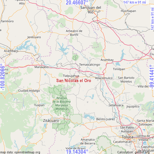
San Nicolás el Oro GPS coordinates[2]
19° 48' 21.348" North, 100° 7' 3.108" West
| Map corner | latitude | longitude |
|---|---|---|
| Upper-left | 20.46607°, | -100.82066° |
| Center: | 19.80593°, | -100.11753° |
| Lower-right: | 19.14304°, | -99.41441° |
| Map W x H: | 147.1×147.1 km | = 91.4×91.4mi |
| max Lat: | 32.7° ⇑47.1% North |
| San Nicolás el Oro: | 19.80593° |
| min Lat: | ⇓52.9% South 14.53588° |
| min Long | San Nicolás el | max Long |
| -117.105° | -100.11753° | -86.73105° |
| W 34.6%⇐ | ⇒65.4% E |
Elevation
Elevation of San Nicolás el Oro is 2724 m = 8937 ft, and this is 1470.3 m = 4824 ft above average elevation for this country.
| Max E: |
3497 m = 11473 ft | 2.3% |
| San Nicolás el Oro | 2724 m 8937 ft | |
| Avg. | 1253.7 m = 4113 ft | |
Min E: |
-1 m = -3 ft | 97.7% |
See also: Mexico elevation on elevation.city.
Geographical zone
San Nicolás el Oro is located in North Torrid zone (between Equator and Tropic of Cancer). Distance of this Northern Tropic circle is 403.7 km =250.8 mi to North.| Distance of | km | miles | from San Nicolás el Oro |
|---|---|---|---|
| North Pole | 7804.8 | 4849.7 | to North |
| Arctic Circle | 5199 | 3230.5 | to North |
| Tropic Cancer | 403.7 | 250.8 | to North |
| Equator | 2202.2 | 1368.4 | to South |


Nearby cities:
15 places around San Nicolás el Oro: (largest is in red/bold)
• Barrio del Gigante
4.9 km =3 mi,  151°
151°
• Barrio la Estrellita
1.3 km =0.8 mi,  305°
305°
• Buenavista
7.7 km =4.8 mi,  94°
94°
• Cerro Llorón
4.6 km =2.9 mi,  184°
184°
• Colonia Cuauhtémoc
3.6 km =2.2 mi,  204°
204°
• El Oro de Hidalgo
1.4 km =0.9 mi,  255°
255°
• Estanzuela (La Hacienda)
7.7 km =4.8 mi,  242°
242°
• La Mesa
4.9 km =3 mi,  224°
224°
• Pata de Mula de los Cedros (Patemula)
7.9 km =4.9 mi,  170°
170°
• Presa Brockman
4.9 km =3 mi,  210°
210°
• San Juan Tlalpujahuilla (Tlalpujahuilla)
5.2 km =3.2 mi,  250°
250°
• Santa Rosa de Lima
3.2 km =2 mi,  134°
134°
• Santiago Oxtempan
2.9 km =1.8 mi,  189°
189°
• Tlalpujahua de Rayón
5.9 km =3.7 mi,  269°
269°
• Zaragoza (Puerto de Medina)
7.6 km =4.7 mi,  359°
359°
Sources, notices
• [Note1] Compared only with cities in Mexico existing in our database
• [Src1] Map data: © OpenStreetMap contributors (CC-BY-SA)
• [Src2] Other city data from geonames.org with taken over terms of usage.
• [Src3] Geographical zone / Annual Mean Temperature by Robert A. Rohde @ Wikipedia
