San Ildefonso geodata
San Ildefonso (State of Mexico) is a populated place; located in Mexico in America/Mexico_City (GMT-6) time zone. With population of 1,178 people, there are 7369 cities with bigger population in this country. Compared to other cities in Mexico, 57.6% of cities are located further ↑North; 65.7% of cities are located further →East and 88.2% of cities have lower elevation than San Ildefonso. Note1


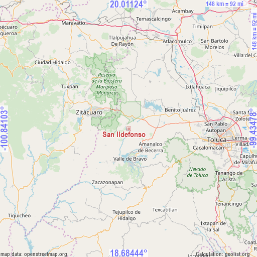
San Ildefonso GPS coordinates[2]
19° 20' 57.084" North, 100° 8' 16.44" West
| Map corner | latitude | longitude |
|---|---|---|
| Upper-left | 20.01124°, | -100.84103° |
| Center: | 19.34919°, | -100.1379° |
| Lower-right: | 18.68444°, | -99.43478° |
| Map W x H: | 147.5×147.5 km | = 91.7×91.7mi |
| max Lat: | 32.7° ⇑57.6% North |
| San Ildefonso: | 19.34919° |
| min Lat: | ⇓42.4% South 14.53588° |
| min Long | San Ildefonso | max Long |
| -117.105° | -100.1379° | -86.73105° |
| W 34.3%⇐ | ⇒65.7% E |
Elevation
Elevation of San Ildefonso is 2348 m = 7703 ft, and this is 1094.3 m = 3590 ft above average elevation for this country.
| Max E: |
3497 m = 11473 ft | 11.8% |
| San Ildefonso | 2348 m 7703 ft | |
| Avg. | 1253.7 m = 4113 ft | |
Min E: |
-1 m = -3 ft | 88.2% |
See also: Mexico elevation on elevation.city.
Geographical zone
San Ildefonso is located in North Torrid zone (between Equator and Tropic of Cancer). Distance of this Northern Tropic circle is 454.5 km =282.4 mi to North.| Distance of | km | miles | from San Ildefonso |
|---|---|---|---|
| North Pole | 7855.6 | 4881.2 | to North |
| Arctic Circle | 5249.7 | 3262 | to North |
| Tropic Cancer | 454.5 | 282.4 | to North |
| Equator | 2151.4 | 1336.8 | to South |


Nearby cities:
15 places around San Ildefonso: (largest is in red/bold)
• Cabecera de Indígenas
2.6 km =1.6 mi,  2°
2°
• Casa Blanca
3.5 km =2.2 mi,  296°
296°
• Loma de San Pablo
6.4 km =4 mi,  320°
320°
• Ranchería de San Martín Obispo
5.7 km =3.5 mi,  117°
117°
• San Agustín de las Palmas
2.8 km =1.7 mi,  204°
204°
• San Antonio Hidalgo (Ranchería de San Antonio)
5.2 km =3.2 mi,  134°
134°
• San Cayetano
5.1 km =3.2 mi,  52°
52°
• San Felipe Santiago
5.6 km =3.5 mi,  35°
35°
• San Isidro
6.7 km =4.2 mi, 44°
• San José Villa de Allende
3.1 km =1.9 mi,  338°
338°
• San Lucas Texcaltitlán
6.5 km =4 mi,  213°
213°
• San Pablo Malacatepec
3.2 km =2 mi, 322°
• Santa María
6 km =3.7 mi, 340°
• Santa Teresa
6.2 km =3.9 mi,  308°
308°
• Vare Chiquichuca
6 km =3.7 mi,  276°
276°
Sources, notices
• [Note1] Compared only with cities in Mexico existing in our database
• [Src1] Map data: © OpenStreetMap contributors (CC-BY-SA)
• [Src2] Other city data from geonames.org with taken over terms of usage.
• [Src3] Geographical zone / Annual Mean Temperature by Robert A. Rohde @ Wikipedia
