San Felipe Santiago geodata
San Felipe Santiago (State of Mexico) is a populated place; located in Mexico in America/Mexico_City (GMT-6) time zone. With population of 3,332 people, there are 2732 cities with bigger population in this country. Compared to other cities in Mexico, 56.5% of cities are located further ↑North; 65.2% of cities are located further →East and 92.6% of cities have lower elevation than San Felipe Santiago. Note1


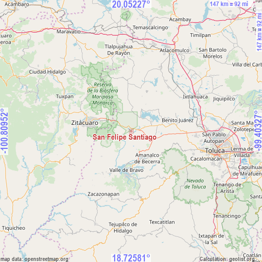
San Felipe Santiago GPS coordinates[2]
19° 23' 25.404" North, 100° 6' 23.004" West
| Map corner | latitude | longitude |
|---|---|---|
| Upper-left | 20.05227°, | -100.80952° |
| Center: | 19.39039°, | -100.10639° |
| Lower-right: | 18.72581°, | -99.40327° |
| Map W x H: | 147.5×147.5 km | = 91.7×91.7mi |
| max Lat: | 32.7° ⇑56.5% North |
| San Felipe Santiago: | 19.39039° |
| min Lat: | ⇓43.5% South 14.53588° |
| min Long | San Felipe Sant | max Long |
| -117.105° | -100.10639° | -86.73105° |
| W 34.8%⇐ | ⇒65.2% E |
Elevation
Elevation of San Felipe Santiago is 2511 m = 8238 ft, and this is 1257.3 m = 4125 ft above average elevation for this country.
| Max E: |
3497 m = 11473 ft | 7.4% |
| San Felipe Santiago | 2511 m 8238 ft | |
| Avg. | 1253.7 m = 4113 ft | |
Min E: |
-1 m = -3 ft | 92.6% |
See also: Mexico elevation on elevation.city.
Geographical zone
San Felipe Santiago is located in North Torrid zone (between Equator and Tropic of Cancer). Distance of this Northern Tropic circle is 449.9 km =279.6 mi to North.| Distance of | km | miles | from San Felipe Santiago |
|---|---|---|---|
| North Pole | 7851.1 | 4878.4 | to North |
| Arctic Circle | 5245.2 | 3259.2 | to North |
| Tropic Cancer | 449.9 | 279.6 | to North |
| Equator | 2156 | 1339.7 | to South |


Nearby cities:
15 places around San Felipe Santiago: (largest is in red/bold)
• Barrio el Boncho
4 km =2.5 mi,  0°
0°
• Barrio la Joya
3.4 km =2.1 mi,  11°
11°
• Barrio los Tules
5.4 km =3.4 mi,  37°
37°
• Cabecera de Indígenas
3.8 km =2.4 mi,  237°
237°
• Dolores Vaquerías
6.6 km =4.1 mi,  68°
68°
• El Jacal
2.4 km =1.5 mi,  47°
47°
• Loma de Juárez
5.3 km =3.3 mi,  18°
18°
• Los Berros
6.1 km =3.8 mi,  82°
82°
• San Cayetano
1.7 km =1.1 mi,  154°
154°
• San Francisco de Asís
3.1 km =1.9 mi,  325°
325°
• San Ildefonso
5.6 km =3.5 mi,  215°
215°
• San Isidro
1.4 km =0.9 mi, 80°
• San José Villa de Allende
4.7 km =2.9 mi,  249°
249°
• San Pablo Malacatepec
5.6 km =3.5 mi, 248°
• Santa María
5.4 km =3.4 mi,  281°
281°
Sources, notices
• [Note1] Compared only with cities in Mexico existing in our database
• [Src1] Map data: © OpenStreetMap contributors (CC-BY-SA)
• [Src2] Other city data from geonames.org with taken over terms of usage.
• [Src3] Geographical zone / Annual Mean Temperature by Robert A. Rohde @ Wikipedia
