Venustiano Carranza geodata
Venustiano Carranza (Colima) is a populated place; located in Mexico in America/Mexico_City (GMT-6) time zone. With population of 1,503 people, there are 5740 cities with bigger population in this country. Compared to other cities in Mexico, 64.5% of cities are located further ↑North; 90.3% of cities are located further →East and 93% of cities have higher elevation than Venustiano Carranza. Note1


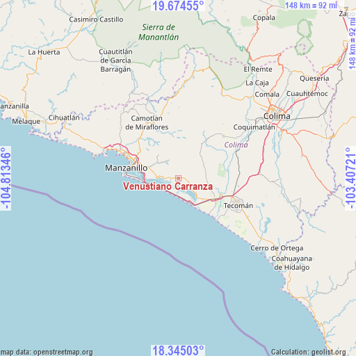
Venustiano Carranza GPS coordinates[2]
19° 0' 40.032" North, 104° 6' 37.188" West
| Map corner | latitude | longitude |
|---|---|---|
| Upper-left | 19.67455°, | -104.81346° |
| Center: | 19.01112°, | -104.11033° |
| Lower-right: | 18.34503°, | -103.40721° |
| Map W x H: | 147.8×147.8 km | = 91.8×91.8mi |
| max Lat: | 32.7° ⇑64.5% North |
| Venustiano Carranza: | 19.01112° |
| min Lat: | ⇓35.5% South 14.53588° |
| min Long | Venustiano Carr | max Long |
| -117.105° | -104.11033° | -86.73105° |
| W 9.7%⇐ | ⇒90.3% E |
Elevation
Elevation of Venustiano Carranza is 17 m = 56 ft, and this is 1236.7 m = 4057 ft below average elevation for this country.
| Max E: |
3497 m = 11473 ft | 93% |
| Avg. | 1253.7 m = 4113 ft | |
| Venustiano Carranza | 17 m = 56 ft | |
Min E: |
-1 m = -3 ft | 7% |
See also: Mexico elevation on elevation.city.
Geographical zone
Venustiano Carranza is located in North Torrid zone (between Equator and Tropic of Cancer). Distance of this Northern Tropic circle is 492.1 km =305.8 mi to North.| Distance of | km | miles | from Venustiano Carranza |
|---|---|---|---|
| North Pole | 7893.2 | 4904.6 | to North |
| Arctic Circle | 5287.3 | 3285.4 | to North |
| Tropic Cancer | 492.1 | 305.8 | to North |
| Equator | 2113.8 | 1313.5 | to South |


Nearby cities:
15 places around Venustiano Carranza: (largest is in red/bold)
• Augusto Gómez Villanueva
11.5 km =7.1 mi,  84°
84°
• Ciudad de Armería
17.4 km =10.8 mi,  117°
117°
• Cofradía de Juárez
17.2 km =10.7 mi,  108°
108°
• Cuyutlán
11.1 km =6.9 mi,  156°
156°
• El Colomo
16.5 km =10.3 mi,  289°
289°
• El Garcero
13.6 km =8.5 mi, 291°
• Francisco Villa
19.2 km =11.9 mi,  304°
304°
• Jalipa
20.6 km =12.8 mi,  306°
306°
• Las Juntas (La Floreña)
12.9 km =8 mi, 292°
• Los Reyes (Zorrillos)
5.9 km =3.7 mi, 123°
• Nuevo Cuyutlán
1.2 km =0.7 mi,  320°
320°
• Rincón de López
19.3 km =12 mi, 75°
• San Buenaventura
5.3 km =3.3 mi,  274°
274°
• Santa Rita
1.8 km =1.1 mi,  86°
86°
• Tapeixtles
19.3 km =12 mi, 289°
Sources, notices
• [Note1] Compared only with cities in Mexico existing in our database
• [Src1] Map data: © OpenStreetMap contributors (CC-BY-SA)
• [Src2] Other city data from geonames.org with taken over terms of usage.
• [Src3] Geographical zone / Annual Mean Temperature by Robert A. Rohde @ Wikipedia
