San Buenaventura geodata
San Buenaventura (Colima) is a populated place; located in Mexico in America/Mexico_City (GMT-6) time zone. With population of 634 people, there are 13664 cities with bigger population in this country. Compared to other cities in Mexico, 64.4% of cities are located further ↑North; 90.4% of cities are located further →East and 95.1% of cities have higher elevation than San Buenaventura. Note1


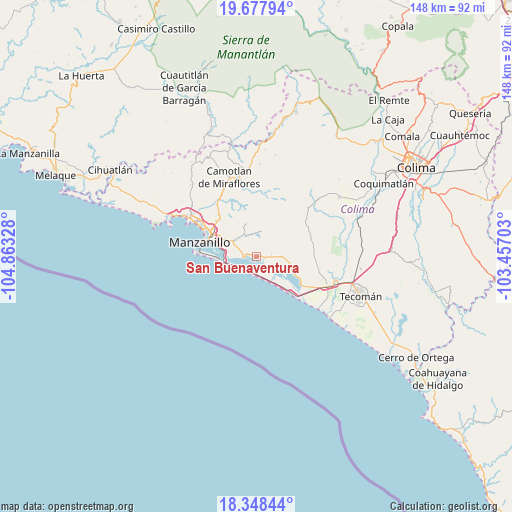
San Buenaventura GPS coordinates[2]
19° 0' 52.272" North, 104° 9' 36.54" West
| Map corner | latitude | longitude |
|---|---|---|
| Upper-left | 19.67794°, | -104.86328° |
| Center: | 19.01452°, | -104.16015° |
| Lower-right: | 18.34844°, | -103.45703° |
| Map W x H: | 147.8×147.8 km | = 91.8×91.8mi |
| max Lat: | 32.7° ⇑64.4% North |
| San Buenaventura: | 19.01452° |
| min Lat: | ⇓35.6% South 14.53588° |
| min Long | San Buenaventur | max Long |
| -117.105° | -104.16015° | -86.73105° |
| W 9.6%⇐ | ⇒90.4% E |
Elevation
Elevation of San Buenaventura is 13 m = 43 ft, and this is 1240.7 m = 4071 ft below average elevation for this country.
| Max E: |
3497 m = 11473 ft | 95.1% |
| Avg. | 1253.7 m = 4113 ft | |
| San Buenaventura | 13 m = 43 ft | |
Min E: |
-1 m = -3 ft | 4.9% |
See also: Mexico elevation on elevation.city.
Geographical zone
San Buenaventura is located in North Torrid zone (between Equator and Tropic of Cancer). Distance of this Northern Tropic circle is 491.7 km =305.5 mi to North.| Distance of | km | miles | from San Buenaventura |
|---|---|---|---|
| North Pole | 7892.8 | 4904.4 | to North |
| Arctic Circle | 5287 | 3285.2 | to North |
| Tropic Cancer | 491.7 | 305.5 | to North |
| Equator | 2114.2 | 1313.7 | to South |


Nearby cities:
15 places around San Buenaventura: (largest is in red/bold)
• Augusto Gómez Villanueva
16.7 km =10.4 mi,  87°
87°
• Ciudad de Armería
22.3 km =13.9 mi,  112°
112°
• Cofradía de Juárez
22.3 km =13.9 mi, 105°
• Cuyutlán
14.3 km =8.9 mi,  137°
137°
• El Colomo
11.6 km =7.2 mi,  296°
296°
• El Garcero
8.7 km =5.4 mi, 301°
• Francisco Villa
14.9 km =9.3 mi,  314°
314°
• Jalipa
16.5 km =10.3 mi,  316°
316°
• Las Juntas (La Floreña)
8.1 km =5 mi, 303°
• Los Reyes (Zorrillos)
10.8 km =6.7 mi, 109°
• Manzanillo
22.3 km =13.9 mi, 300°
• Nuevo Cuyutlán
4.5 km =2.8 mi,  82°
82°
• Santa Rita
7 km =4.3 mi, 92°
• Tapeixtles
14.3 km =8.9 mi, 295°
• Venustiano Carranza
5.3 km =3.3 mi, 94°
Sources, notices
• [Note1] Compared only with cities in Mexico existing in our database
• [Src1] Map data: © OpenStreetMap contributors (CC-BY-SA)
• [Src2] Other city data from geonames.org with taken over terms of usage.
• [Src3] Geographical zone / Annual Mean Temperature by Robert A. Rohde @ Wikipedia
