Los Baños geodata
Los Baños (Querétaro) is a populated place; located in Mexico in America/Mexico_City (GMT-6) time zone. With population of 1,801 people, there are 4831 cities with bigger population in this country. Compared to other cities in Mexico, 73.2% of cities are located further ↓South; 67.5% of cities are located further →East and 74.7% of cities have lower elevation than Los Baños. Note1


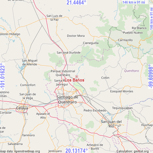
Los Baños GPS coordinates[2]
20° 47' 25.8" North, 100° 18' 47.16" West
| Map corner | latitude | longitude |
|---|---|---|
| Upper-left | 21.4464°, | -101.01623° |
| Center: | 20.7905°, | -100.3131° |
| Lower-right: | 20.13174°, | -99.60998° |
| Map W x H: | 146.2×146.2 km | = 90.8×90.8mi |
| max Lat: | 32.7° ⇑26.8% North |
| Los Baños: | 20.7905° |
| min Lat: | ⇓73.2% South 14.53588° |
| min Long | Los Baños | max Long |
| -117.105° | -100.3131° | -86.73105° |
| W 32.5%⇐ | ⇒67.5% E |
Elevation
Elevation of Los Baños is 2024 m = 6640 ft, and this is 770.3 m = 2527 ft above average elevation for this country.
| Max E: |
3497 m = 11473 ft | 25.3% |
| Los Baños | 2024 m 6640 ft | |
| Avg. | 1253.7 m = 4113 ft | |
Min E: |
-1 m = -3 ft | 74.7% |
See also: Mexico elevation on elevation.city.
Geographical zone
Los Baños is located in North Torrid zone (between Equator and Tropic of Cancer). Distance of this Northern Tropic circle is 294.2 km =182.8 mi to North.| Distance of | km | miles | from Los Baños |
|---|---|---|---|
| North Pole | 7695.4 | 4781.7 | to North |
| Arctic Circle | 5089.5 | 3162.5 | to North |
| Tropic Cancer | 294.2 | 182.8 | to North |
| Equator | 2311.7 | 1436.4 | to South |


Nearby cities:
15 places around Los Baños: (largest is in red/bold)
• Atongo
7.9 km =4.9 mi,  104°
104°
• Chichimequillas
3.7 km =2.3 mi,  220°
220°
• El Pinto
10.3 km =6.4 mi,  277°
277°
• La Estacada
10.4 km =6.5 mi,  289°
289°
• La Laborcilla
9.4 km =5.8 mi,  15°
15°
• La Solana
10.3 km =6.4 mi,  235°
235°
• Las Lajitas
9.3 km =5.8 mi, 279°
• Los Pocitos
1.1 km =0.7 mi,  354°
354°
• Presa de Rayas
9.6 km =6 mi,  78°
78°
• San Miguel Amazcala
9.2 km =5.7 mi,  118°
118°
• San Rafael
5.1 km =3.2 mi,  146°
146°
• San Vicente Ferrer
7.8 km =4.8 mi,  205°
205°
• Santa Cruz
8.8 km =5.5 mi,  173°
173°
• Santa María Begoña
4.9 km =3 mi,  185°
185°
• Tierra Blanca
7 km =4.3 mi,  260°
260°
Sources, notices
• [Note1] Compared only with cities in Mexico existing in our database
• [Src1] Map data: © OpenStreetMap contributors (CC-BY-SA)
• [Src2] Other city data from geonames.org with taken over terms of usage.
• [Src3] Geographical zone / Annual Mean Temperature by Robert A. Rohde @ Wikipedia
