Jesús María geodata
Jesús María (Querétaro) is a populated place; located in Mexico in America/Mexico_City (GMT-6) time zone. With population of 2,978 people, there are 3009 cities with bigger population in this country. Compared to other cities in Mexico, 70.4% of cities are located further ↓South; 66.9% of cities are located further →East and 68.6% of cities have lower elevation than Jesús María. Note1


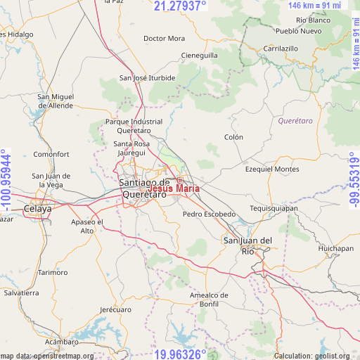
Jesús María GPS coordinates[2]
20° 37' 21.864" North, 100° 15' 22.716" West
| Map corner | latitude | longitude |
|---|---|---|
| Upper-left | 21.27937°, | -100.95944° |
| Center: | 20.62274°, | -100.25631° |
| Lower-right: | 19.96326°, | -99.55319° |
| Map W x H: | 146.3×146.3 km | = 90.9×90.9mi |
| max Lat: | 32.7° ⇑29.6% North |
| Jesús María: | 20.62274° |
| min Lat: | ⇓70.4% South 14.53588° |
| min Long | Jesús María | max Long |
| -117.105° | -100.25631° | -86.73105° |
| W 33.1%⇐ | ⇒66.9% E |
Elevation
Elevation of Jesús María is 1900 m = 6234 ft, and this is 646.3 m = 2120 ft above average elevation for this country.
| Max E: |
3497 m = 11473 ft | 31.4% |
| Jesús María | 1900 m 6234 ft | |
| Avg. | 1253.7 m = 4113 ft | |
Min E: |
-1 m = -3 ft | 68.6% |
See also: Mexico elevation on elevation.city.
Geographical zone
Jesús María is located in North Torrid zone (between Equator and Tropic of Cancer). Distance of this Northern Tropic circle is 312.9 km =194.4 mi to North.| Distance of | km | miles | from Jesús María |
|---|---|---|---|
| North Pole | 7714 | 4793.3 | to North |
| Arctic Circle | 5108.1 | 3174 | to North |
| Tropic Cancer | 312.9 | 194.4 | to North |
| Equator | 2293 | 1424.8 | to South |


Nearby cities:
15 places around Jesús María: (largest is in red/bold)
• Agua Azul
5.8 km =3.6 mi,  112°
112°
• Cerrito Colorado
0.8 km =0.5 mi,  71°
71°
• Cerro Prieto
4.6 km =2.9 mi,  310°
310°
• Coyotillos
5.6 km =3.5 mi,  117°
117°
• El Carmen
6.3 km =3.9 mi,  211°
211°
• Guadalupe la Venta
4.4 km =2.7 mi,  55°
55°
• Hacienda la Cruz [Fraccionamiento]
1.4 km =0.9 mi,  330°
330°
• La Griega
5.1 km =3.2 mi,  19°
19°
• La Loma
3.1 km =1.9 mi,  144°
144°
• La Piedad
4.9 km =3 mi,  179°
179°
• La Trinidad
4.2 km =2.6 mi,  286°
286°
• Paseos del Marqués
2.7 km =1.7 mi, 141°
• Saldarriaga
3.9 km =2.4 mi,  278°
278°
• Santa Fe Libertadores
4.6 km =2.9 mi,  354°
354°
• Santa María Ticomán
5.3 km =3.3 mi, 352°
Sources, notices
• [Note1] Compared only with cities in Mexico existing in our database
• [Src1] Map data: © OpenStreetMap contributors (CC-BY-SA)
• [Src2] Other city data from geonames.org with taken over terms of usage.
• [Src3] Geographical zone / Annual Mean Temperature by Robert A. Rohde @ Wikipedia
