Paseos del Marqués geodata
Paseos del Marqués (Querétaro) is a populated place; located in Mexico in America/Mexico_City (GMT-6) time zone. With population of 1,342 people, there are 6480 cities with bigger population in this country. Compared to other cities in Mexico, 70.1% of cities are located further ↓South; 66.8% of cities are located further →East and 69.1% of cities have lower elevation than Paseos del Marqués. Note1


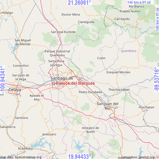
Paseos del Marqués GPS coordinates[2]
20° 36' 14.004" North, 100° 14' 25.008" West
| Map corner | latitude | longitude |
|---|---|---|
| Upper-left | 21.26061°, | -100.94341° |
| Center: | 20.60389°, | -100.24028° |
| Lower-right: | 19.94433°, | -99.53716° |
| Map W x H: | 146.4×146.4 km | = 91×91mi |
| max Lat: | 32.7° ⇑29.9% North |
| Paseos del Marqués: | 20.60389° |
| min Lat: | ⇓70.1% South 14.53588° |
| min Long | Paseos del Marq | max Long |
| -117.105° | -100.24028° | -86.73105° |
| W 33.2%⇐ | ⇒66.8% E |
Elevation
Elevation of Paseos del Marqués is 1910 m = 6266 ft, and this is 656.3 m = 2153 ft above average elevation for this country.
| Max E: |
3497 m = 11473 ft | 30.9% |
| Paseos del Marqués | 1910 m 6266 ft | |
| Avg. | 1253.7 m = 4113 ft | |
Min E: |
-1 m = -3 ft | 69.1% |
See also: Mexico elevation on elevation.city.
Geographical zone
Paseos del Marqués is located in North Torrid zone (between Equator and Tropic of Cancer). Distance of this Northern Tropic circle is 315 km =195.7 mi to North.| Distance of | km | miles | from Paseos del Marqués |
|---|---|---|---|
| North Pole | 7716.1 | 4794.6 | to North |
| Arctic Circle | 5110.2 | 3175.3 | to North |
| Tropic Cancer | 315 | 195.7 | to North |
| Equator | 2290.9 | 1423.5 | to South |


Nearby cities:
15 places around Paseos del Marqués: (largest is in red/bold)
• Agua Azul
3.7 km =2.3 mi,  92°
92°
• Cerrito Colorado
2.5 km =1.6 mi,  338°
338°
• Coyotillos
3.3 km =2.1 mi,  98°
98°
• El Carmen
6 km =3.7 mi,  236°
236°
• El Colorado
4.7 km =2.9 mi,  186°
186°
• El Paraíso
5.1 km =3.2 mi,  150°
150°
• General Lázaro Cárdenas (El Colorado)
4.5 km =2.8 mi,  184°
184°
• Guadalupe la Venta
5 km =3.1 mi,  23°
23°
• Hacienda la Cruz [Fraccionamiento]
4 km =2.5 mi,  324°
324°
• Jesús María
2.7 km =1.7 mi, 321°
• La Loma
0.5 km =0.3 mi,  161°
161°
• La Piedad
3.2 km =2 mi,  210°
210°
• Saldarriaga
6.1 km =3.8 mi,  295°
295°
• San Cristobal (El Colorado)
5.4 km =3.4 mi, 193°
• Viborillas
5.7 km =3.5 mi,  84°
84°
Sources, notices
• [Note1] Compared only with cities in Mexico existing in our database
• [Src1] Map data: © OpenStreetMap contributors (CC-BY-SA)
• [Src2] Other city data from geonames.org with taken over terms of usage.
• [Src3] Geographical zone / Annual Mean Temperature by Robert A. Rohde @ Wikipedia
