Santa Fe Libertadores geodata
Santa Fe Libertadores (Querétaro) is a populated place; located in Mexico in America/Mexico_City (GMT-6) time zone. With population of 603 people, there are 14266 cities with bigger population in this country. Compared to other cities in Mexico, 71.1% of cities are located further ↓South; 67% of cities are located further →East and 68.8% of cities have lower elevation than Santa Fe Libertadores. Note1


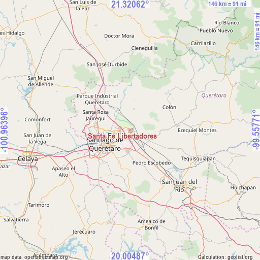
Santa Fe Libertadores GPS coordinates[2]
20° 39' 51.012" North, 100° 15' 38.988" West
| Map corner | latitude | longitude |
|---|---|---|
| Upper-left | 21.32062°, | -100.96396° |
| Center: | 20.66417°, | -100.26083° |
| Lower-right: | 20.00487°, | -99.55771° |
| Map W x H: | 146.3×146.3 km | = 90.9×90.9mi |
| max Lat: | 32.7° ⇑28.9% North |
| Santa Fe Libertadores: | 20.66417° |
| min Lat: | ⇓71.1% South 14.53588° |
| min Long | Santa Fe Libert | max Long |
| -117.105° | -100.26083° | -86.73105° |
| W 33%⇐ | ⇒67% E |
Elevation
Elevation of Santa Fe Libertadores is 1904 m = 6247 ft, and this is 650.3 m = 2134 ft above average elevation for this country.
| Max E: |
3497 m = 11473 ft | 31.2% |
| Santa Fe Libertadores | 1904 m 6247 ft | |
| Avg. | 1253.7 m = 4113 ft | |
Min E: |
-1 m = -3 ft | 68.8% |
See also: Mexico elevation on elevation.city.
Geographical zone
Santa Fe Libertadores is located in North Torrid zone (between Equator and Tropic of Cancer). Distance of this Northern Tropic circle is 308.3 km =191.6 mi to North.| Distance of | km | miles | from Santa Fe Libertadores |
|---|---|---|---|
| North Pole | 7709.4 | 4790.4 | to North |
| Arctic Circle | 5103.5 | 3171.2 | to North |
| Tropic Cancer | 308.3 | 191.6 | to North |
| Equator | 2297.6 | 1427.7 | to South |


Nearby cities:
15 places around Santa Fe Libertadores: (largest is in red/bold)
• Amazcala
4.4 km =2.7 mi,  354°
354°
• Cerrito Colorado
4.5 km =2.8 mi,  164°
164°
• Cerro Prieto
3.5 km =2.2 mi,  242°
242°
• El Pozo
8.1 km =5 mi,  248°
248°
• Guadalupe la Venta
4.6 km =2.9 mi,  117°
117°
• Hacienda la Cruz [Fraccionamiento]
3.4 km =2.1 mi,  183°
183°
• Jesús María
4.6 km =2.9 mi,  174°
174°
• La Griega
2.2 km =1.4 mi,  83°
83°
• La Loma
7.5 km =4.7 mi, 162°
• La Pradera
8.5 km =5.3 mi,  266°
266°
• La Trinidad
4.9 km =3 mi,  225°
225°
• Paseos del Marqués
7 km =4.3 mi, 162°
• Saldarriaga
5.3 km =3.3 mi,  219°
219°
• Santa Cruz
7 km =4.3 mi,  319°
319°
• Santa María Ticomán
0.7 km =0.4 mi,  338°
338°
Sources, notices
• [Note1] Compared only with cities in Mexico existing in our database
• [Src1] Map data: © OpenStreetMap contributors (CC-BY-SA)
• [Src2] Other city data from geonames.org with taken over terms of usage.
• [Src3] Geographical zone / Annual Mean Temperature by Robert A. Rohde @ Wikipedia
