Bravo geodata
Bravo (Querétaro) is a populated place; located in Mexico in America/Mexico_City (GMT-6) time zone. With population of 1,407 people, there are 6150 cities with bigger population in this country. Compared to other cities in Mexico, 65.6% of cities are located further ↓South; 68.7% of cities are located further →East and 79.6% of cities have lower elevation than Bravo. Note1


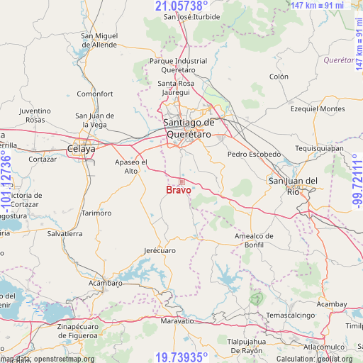
Bravo GPS coordinates[2]
20° 23' 59.172" North, 100° 25' 27.228" West
| Map corner | latitude | longitude |
|---|---|---|
| Upper-left | 21.05738°, | -101.12736° |
| Center: | 20.39977°, | -100.42423° |
| Lower-right: | 19.73935°, | -99.72111° |
| Map W x H: | 146.6×146.6 km | = 91.1×91.1mi |
| max Lat: | 32.7° ⇑34.4% North |
| Bravo: | 20.39977° |
| min Lat: | ⇓65.6% South 14.53588° |
| min Long | Bravo | max Long |
| -117.105° | -100.42423° | -86.73105° |
| W 31.3%⇐ | ⇒68.7% E |
Elevation
Elevation of Bravo is 2130 m = 6988 ft, and this is 876.3 m = 2875 ft above average elevation for this country.
| Max E: |
3497 m = 11473 ft | 20.4% |
| Bravo | 2130 m 6988 ft | |
| Avg. | 1253.7 m = 4113 ft | |
Min E: |
-1 m = -3 ft | 79.6% |
See also: Mexico elevation on elevation.city.
Geographical zone
Bravo is located in North Torrid zone (between Equator and Tropic of Cancer). Distance of this Northern Tropic circle is 337.7 km =209.8 mi to North.| Distance of | km | miles | from Bravo |
|---|---|---|---|
| North Pole | 7738.8 | 4808.7 | to North |
| Arctic Circle | 5132.9 | 3189.4 | to North |
| Tropic Cancer | 337.7 | 209.8 | to North |
| Equator | 2268.2 | 1409.4 | to South |


Nearby cities:
15 places around Bravo: (largest is in red/bold)
• Apapátaro
9.6 km =6 mi,  37°
37°
• Buenavista
5.3 km =3.3 mi,  105°
105°
• Candelas
10 km =6.2 mi,  194°
194°
• Ceja de Bravo
3.9 km =2.4 mi,  127°
127°
• Charco Blanco
6.3 km =3.9 mi,  307°
307°
• El Jaral
3.3 km =2.1 mi,  282°
282°
• El Vegil
8.5 km =5.3 mi,  65°
65°
• Huitrón
7.1 km =4.4 mi, 113°
• Joaquín Herrera
9.4 km =5.8 mi,  350°
350°
• Las Taponas
4.6 km =2.9 mi,  64°
64°
• Presa de Bravo
3.2 km =2 mi,  358°
358°
• Puerta de San Rafael
4.3 km =2.7 mi,  30°
30°
• San José Tepuzas
7.2 km =4.5 mi, 134°
• San Rafael
6.7 km =4.2 mi, 28°
• Santa Cruz de Gamboa
9.7 km =6 mi,  263°
263°
Sources, notices
• [Note1] Compared only with cities in Mexico existing in our database
• [Src1] Map data: © OpenStreetMap contributors (CC-BY-SA)
• [Src2] Other city data from geonames.org with taken over terms of usage.
• [Src3] Geographical zone / Annual Mean Temperature by Robert A. Rohde @ Wikipedia
