Huitrón geodata
Huitrón (Querétaro) is a populated place; located in Mexico in America/Mexico_City (GMT-6) time zone. With population of 611 people, there are 14112 cities with bigger population in this country. Compared to other cities in Mexico, 65.1% of cities are located further ↓South; 68% of cities are located further →East and 83.1% of cities have lower elevation than Huitrón. Note1


Huitrón GPS coordinates[2]
20° 22' 28.308" North, 100° 21' 40.284" West
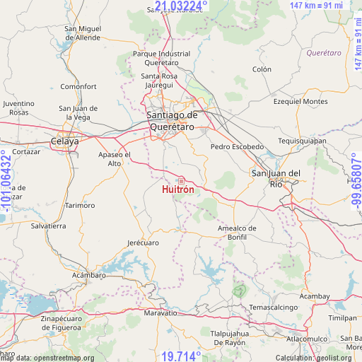
| Map corner | latitude | longitude |
|---|---|---|
| Upper-left | 21.03224°, | -101.06432° |
| Center: | 20.37453°, | -100.36119° |
| Lower-right: | 19.714°, | -99.65807° |
| Map W x H: | 146.6×146.6 km | = 91.1×91.1mi |
| max Lat: | 32.7° ⇑34.9% North |
| Huitrón: | 20.37453° |
| min Lat: | ⇓65.1% South 14.53588° |
| min Long | Huitrón | max Long |
| -117.105° | -100.36119° | -86.73105° |
| W 32%⇐ | ⇒68% E |
Elevation
Elevation of Huitrón is 2219 m = 7280 ft, and this is 965.3 m = 3167 ft above average elevation for this country.
| Max E: |
3497 m = 11473 ft | 16.9% |
| Huitrón | 2219 m 7280 ft | |
| Avg. | 1253.7 m = 4113 ft | |
Min E: |
-1 m = -3 ft | 83.1% |
See also: Mexico elevation on elevation.city.
Geographical zone
Huitrón is located in North Torrid zone (between Equator and Tropic of Cancer). Distance of this Northern Tropic circle is 340.5 km =211.6 mi to North.| Distance of | km | miles | from Huitrón |
|---|---|---|---|
| North Pole | 7741.6 | 4810.4 | to North |
| Arctic Circle | 5135.7 | 3191.2 | to North |
| Tropic Cancer | 340.5 | 211.6 | to North |
| Equator | 2265.4 | 1407.7 | to South |


Nearby cities:
15 places around Huitrón: (largest is in red/bold)
• Apapátaro
10.4 km =6.5 mi,  355°
355°
• Bravo
7.1 km =4.4 mi,  293°
293°
• Buenavista
2.1 km =1.3 mi,  313°
313°
• Ceja de Bravo
3.5 km =2.2 mi,  277°
277°
• El Granjeno
6.5 km =4 mi,  38°
38°
• El Jaral
10.4 km =6.5 mi, 289°
• El Vegil
6.4 km =4 mi,  10°
10°
• Huimilpan
8.7 km =5.4 mi,  91°
91°
• La Ceja
10 km =6.2 mi, 86°
• Las Taponas
5.3 km =3.3 mi,  333°
333°
• Presa de Bravo
8.9 km =5.5 mi, 311°
• Puerta de San Rafael
7.8 km =4.8 mi, 325°
• San José Tepuzas
2.7 km =1.7 mi,  212°
212°
• San Pedro
10 km =6.2 mi,  126°
126°
• San Rafael
9.4 km =5.8 mi,  338°
338°
Sources, notices
• [Note1] Compared only with cities in Mexico existing in our database
• [Src1] Map data: © OpenStreetMap contributors (CC-BY-SA)
• [Src2] Other city data from geonames.org with taken over terms of usage.
• [Src3] Geographical zone / Annual Mean Temperature by Robert A. Rohde @ Wikipedia
