Las Taponas geodata
Las Taponas (Querétaro) is a populated place; located in Mexico in America/Mexico_City (GMT-6) time zone. With population of 1,994 people, there are 4365 cities with bigger population in this country. Compared to other cities in Mexico, 66% of cities are located further ↓South; 68.3% of cities are located further →East and 77.4% of cities have lower elevation than Las Taponas. Note1


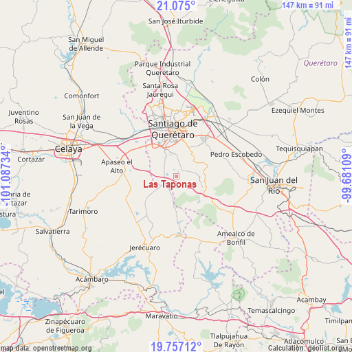
Las Taponas GPS coordinates[2]
20° 25' 2.892" North, 100° 23' 3.156" West
| Map corner | latitude | longitude |
|---|---|---|
| Upper-left | 21.075°, | -101.08734° |
| Center: | 20.41747°, | -100.38421° |
| Lower-right: | 19.75712°, | -99.68109° |
| Map W x H: | 146.5×146.5 km | = 91×91mi |
| max Lat: | 32.7° ⇑34% North |
| Las Taponas: | 20.41747° |
| min Lat: | ⇓66% South 14.53588° |
| min Long | Las Taponas | max Long |
| -117.105° | -100.38421° | -86.73105° |
| W 31.7%⇐ | ⇒68.3% E |
Elevation
Elevation of Las Taponas is 2075 m = 6808 ft, and this is 821.3 m = 2695 ft above average elevation for this country.
| Max E: |
3497 m = 11473 ft | 22.6% |
| Las Taponas | 2075 m 6808 ft | |
| Avg. | 1253.7 m = 4113 ft | |
Min E: |
-1 m = -3 ft | 77.4% |
See also: Mexico elevation on elevation.city.
Geographical zone
Las Taponas is located in North Torrid zone (between Equator and Tropic of Cancer). Distance of this Northern Tropic circle is 335.7 km =208.6 mi to North.| Distance of | km | miles | from Las Taponas |
|---|---|---|---|
| North Pole | 7736.9 | 4807.5 | to North |
| Arctic Circle | 5131 | 3188.3 | to North |
| Tropic Cancer | 335.7 | 208.6 | to North |
| Equator | 2270.2 | 1410.6 | to South |


Nearby cities:
15 places around Las Taponas: (largest is in red/bold)
• Apapátaro
5.9 km =3.7 mi,  16°
16°
• Bravo
4.6 km =2.9 mi,  244°
244°
• Buenavista
3.5 km =2.2 mi,  164°
164°
• Ceja de Bravo
4.5 km =2.8 mi,  193°
193°
• Charco Blanco
9.4 km =5.8 mi,  281°
281°
• El Granjeno
6.4 km =4 mi,  86°
86°
• El Jaral
7.5 km =4.7 mi,  260°
260°
• El Milagro
7.3 km =4.5 mi,  30°
30°
• El Vegil
3.9 km =2.4 mi,  66°
66°
• Huitrón
5.3 km =3.3 mi,  153°
153°
• Joaquín Herrera
9.2 km =5.7 mi,  322°
322°
• Presa de Bravo
4.4 km =2.7 mi,  285°
285°
• Puerta de San Rafael
2.6 km =1.6 mi,  310°
310°
• San José Tepuzas
7.1 km =4.4 mi,  172°
172°
• San Rafael
4.1 km =2.5 mi,  345°
345°
Sources, notices
• [Note1] Compared only with cities in Mexico existing in our database
• [Src1] Map data: © OpenStreetMap contributors (CC-BY-SA)
• [Src2] Other city data from geonames.org with taken over terms of usage.
• [Src3] Geographical zone / Annual Mean Temperature by Robert A. Rohde @ Wikipedia
