Laguna de Servín geodata
Laguna de Servín (Querétaro) is a populated place; located in Mexico in America/Mexico_City (GMT-6) time zone. With population of 786 people, there are 11112 cities with bigger population in this country. Compared to other cities in Mexico, 62.9% of cities are located further ↓South; 67.1% of cities are located further →East and 98.2% of cities have lower elevation than Laguna de Servín. Note1


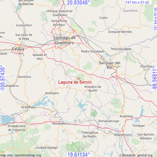
Laguna de Servín GPS coordinates[2]
20° 16' 20.28" North, 100° 16' 16.428" West
| Map corner | latitude | longitude |
|---|---|---|
| Upper-left | 20.93046°, | -100.97436° |
| Center: | 20.2723°, | -100.27123° |
| Lower-right: | 19.61134°, | -99.56811° |
| Map W x H: | 146.7×146.7 km | = 91.2×91.2mi |
| max Lat: | 32.7° ⇑37.1% North |
| Laguna de Servín: | 20.2723° |
| min Lat: | ⇓62.9% South 14.53588° |
| min Long | Laguna de Serv� | max Long |
| -117.105° | -100.27123° | -86.73105° |
| W 32.9%⇐ | ⇒67.1% E |
Elevation
Elevation of Laguna de Servín is 2767 m = 9078 ft, and this is 1513.3 m = 4965 ft above average elevation for this country.
| Max E: |
3497 m = 11473 ft | 1.8% |
| Laguna de Servín | 2767 m 9078 ft | |
| Avg. | 1253.7 m = 4113 ft | |
Min E: |
-1 m = -3 ft | 98.2% |
See also: Mexico elevation on elevation.city.
Geographical zone
Laguna de Servín is located in North Torrid zone (between Equator and Tropic of Cancer). Distance of this Northern Tropic circle is 351.9 km =218.7 mi to North.| Distance of | km | miles | from Laguna de Servín |
|---|---|---|---|
| North Pole | 7753 | 4817.5 | to North |
| Arctic Circle | 5147.1 | 3198.3 | to North |
| Tropic Cancer | 351.9 | 218.7 | to North |
| Equator | 2254.1 | 1400.6 | to South |


Nearby cities:
15 places around Laguna de Servín: (largest is in red/bold)
• Cerro Colorado
9.6 km =6 mi,  244°
244°
• Coroneo
12.7 km =7.9 mi,  230°
230°
• El Capulín
10.9 km =6.8 mi, 242°
• El Rincón
7 km =4.3 mi,  98°
98°
• El Sauz de Cebolletas
10.9 km =6.8 mi,  264°
264°
• Huimilpan
11.1 km =6.9 mi,  356°
356°
• Huitrón
14.7 km =9.1 mi,  320°
320°
• La Alameda del Rincón
5.5 km =3.4 mi,  77°
77°
• La Ceja
12 km =7.5 mi,  3°
3°
• La Luz
5 km =3.1 mi,  270°
270°
• La Soledad
14.2 km =8.8 mi,  143°
143°
• Piedra Larga
6.6 km =4.1 mi, 259°
• San José Tepuzas
14.2 km =8.8 mi,  309°
309°
• San Martín
11.3 km =7 mi, 99°
• San Pedro
5.5 km =3.4 mi,  345°
345°
Sources, notices
• [Note1] Compared only with cities in Mexico existing in our database
• [Src1] Map data: © OpenStreetMap contributors (CC-BY-SA)
• [Src2] Other city data from geonames.org with taken over terms of usage.
• [Src3] Geographical zone / Annual Mean Temperature by Robert A. Rohde @ Wikipedia
