La Ceja geodata
La Ceja (Querétaro) is a populated place; located in Mexico in America/Mexico_City (GMT-6) time zone. With population of 1,940 people, there are 4485 cities with bigger population in this country. Compared to other cities in Mexico, 65.2% of cities are located further ↓South; 67% of cities are located further →East and 86.6% of cities have lower elevation than La Ceja. Note1


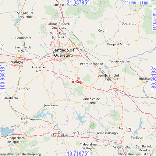
La Ceja GPS coordinates[2]
20° 22' 48.936" North, 100° 15' 54.18" West
| Map corner | latitude | longitude |
|---|---|---|
| Upper-left | 21.03795°, | -100.96818° |
| Center: | 20.38026°, | -100.26505° |
| Lower-right: | 19.71975°, | -99.56193° |
| Map W x H: | 146.6×146.6 km | = 91.1×91.1mi |
| max Lat: | 32.7° ⇑34.8% North |
| La Ceja: | 20.38026° |
| min Lat: | ⇓65.2% South 14.53588° |
| min Long | La Ceja | max Long |
| -117.105° | -100.26505° | -86.73105° |
| W 33%⇐ | ⇒67% E |
Elevation
Elevation of La Ceja is 2299 m = 7543 ft, and this is 1045.3 m = 3429 ft above average elevation for this country.
| Max E: |
3497 m = 11473 ft | 13.4% |
| La Ceja | 2299 m 7543 ft | |
| Avg. | 1253.7 m = 4113 ft | |
Min E: |
-1 m = -3 ft | 86.6% |
See also: Mexico elevation on elevation.city.
Geographical zone
La Ceja is located in North Torrid zone (between Equator and Tropic of Cancer). Distance of this Northern Tropic circle is 339.8 km =211.1 mi to North.| Distance of | km | miles | from La Ceja |
|---|---|---|---|
| North Pole | 7741 | 4810 | to North |
| Arctic Circle | 5135.1 | 3190.8 | to North |
| Tropic Cancer | 339.8 | 211.1 | to North |
| Equator | 2266.1 | 1408.1 | to South |


Nearby cities:
15 places around La Ceja: (largest is in red/bold)
• Ajuchitlancito
11.8 km =7.3 mi,  25°
25°
• Buenavista
11.5 km =7.1 mi,  273°
273°
• El Granjeno
7.5 km =4.7 mi,  306°
306°
• El Vegil
10.5 km =6.5 mi,  302°
302°
• Escolasticas
7.7 km =4.8 mi,  46°
46°
• Guadalupe Primero
12.1 km =7.5 mi,  340°
340°
• Huimilpan
1.6 km =1 mi,  234°
234°
• Huitrón
10 km =6.2 mi, 266°
• La Alameda del Rincón
11.8 km =7.3 mi,  156°
156°
• Laguna de Servín
12 km =7.5 mi,  183°
183°
• Lagunillas
9.3 km =5.8 mi, 340°
• San Antonio la D
11.5 km =7.1 mi,  66°
66°
• San Cirilo
7.5 km =4.7 mi,  61°
61°
• San José Tepuzas
11.9 km =7.4 mi,  255°
255°
• San Pedro
6.9 km =4.3 mi,  197°
197°
Sources, notices
• [Note1] Compared only with cities in Mexico existing in our database
• [Src1] Map data: © OpenStreetMap contributors (CC-BY-SA)
• [Src2] Other city data from geonames.org with taken over terms of usage.
• [Src3] Geographical zone / Annual Mean Temperature by Robert A. Rohde @ Wikipedia
