La Luz geodata
La Luz (Michoacán) is a populated place; located in Mexico in America/Mexico_City (GMT-6) time zone. With population of 676 people, there are 12846 cities with bigger population in this country. Compared to other cities in Mexico, 62.9% of cities are located further ↓South; 67.6% of cities are located further →East and 92.3% of cities have lower elevation than La Luz. Note1


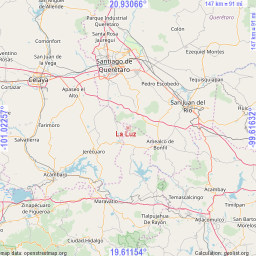
La Luz GPS coordinates[2]
20° 16' 21" North, 100° 19' 9.984" West
| Map corner | latitude | longitude |
|---|---|---|
| Upper-left | 20.93066°, | -101.02257° |
| Center: | 20.2725°, | -100.31944° |
| Lower-right: | 19.61154°, | -99.61632° |
| Map W x H: | 146.7×146.7 km | = 91.2×91.2mi |
| max Lat: | 32.7° ⇑37.1% North |
| La Luz: | 20.2725° |
| min Lat: | ⇓62.9% South 14.53588° |
| min Long | La Luz | max Long |
| -117.105° | -100.31944° | -86.73105° |
| W 32.4%⇐ | ⇒67.6% E |
Elevation
Elevation of La Luz is 2496 m = 8189 ft, and this is 1242.3 m = 4076 ft above average elevation for this country.
| Max E: |
3497 m = 11473 ft | 7.7% |
| La Luz | 2496 m 8189 ft | |
| Avg. | 1253.7 m = 4113 ft | |
Min E: |
-1 m = -3 ft | 92.3% |
See also: Mexico elevation on elevation.city.
Geographical zone
La Luz is located in North Torrid zone (between Equator and Tropic of Cancer). Distance of this Northern Tropic circle is 351.8 km =218.6 mi to North.| Distance of | km | miles | from La Luz |
|---|---|---|---|
| North Pole | 7753 | 4817.5 | to North |
| Arctic Circle | 5147.1 | 3198.3 | to North |
| Tropic Cancer | 351.8 | 218.6 | to North |
| Equator | 2254.1 | 1400.6 | to South |


Nearby cities:
15 places around La Luz: (largest is in red/bold)
• Buenavista
14 km =8.7 mi,  335°
335°
• Cerro Colorado
5.5 km =3.4 mi,  221°
221°
• Coroneo
9.4 km =5.8 mi,  210°
210°
• El Capulín
6.8 km =4.2 mi, 223°
• El Rincón
11.9 km =7.4 mi,  95°
95°
• El Sauz de Cebolletas
5.9 km =3.7 mi,  259°
259°
• Huimilpan
11.9 km =7.4 mi,  21°
21°
• Huitrón
12.2 km =7.6 mi, 339°
• La Alameda del Rincón
10.4 km =6.5 mi,  83°
83°
• La Ceja
13.3 km =8.3 mi,  25°
25°
• La Huerta
12.2 km =7.6 mi,  225°
225°
• Laguna de Servín
5 km =3.1 mi,  90°
90°
• Piedra Larga
1.9 km =1.2 mi, 231°
• San José Tepuzas
10.8 km =6.7 mi,  327°
327°
• San Pedro
6.5 km =4 mi, 34°
Sources, notices
• [Note1] Compared only with cities in Mexico existing in our database
• [Src1] Map data: © OpenStreetMap contributors (CC-BY-SA)
• [Src2] Other city data from geonames.org with taken over terms of usage.
• [Src3] Geographical zone / Annual Mean Temperature by Robert A. Rohde @ Wikipedia
