El Lindero geodata
El Lindero (Querétaro) is a populated place; located in Mexico in America/Mexico_City (GMT-6) time zone. With population of 894 people, there are 9757 cities with bigger population in this country. Compared to other cities in Mexico, 59.2% of cities are located further ↓South; 65.6% of cities are located further →East and 90.6% of cities have lower elevation than El Lindero. Note1


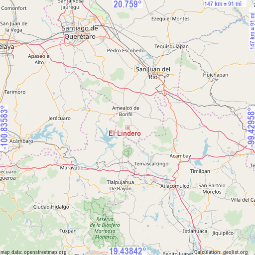
El Lindero GPS coordinates[2]
20° 6' 0.36" North, 100° 7' 57.72" West
| Map corner | latitude | longitude |
|---|---|---|
| Upper-left | 20.759°, | -100.83583° |
| Center: | 20.1001°, | -100.1327° |
| Lower-right: | 19.43842°, | -99.42958° |
| Map W x H: | 146.8×146.8 km | = 91.2×91.2mi |
| max Lat: | 32.7° ⇑40.8% North |
| El Lindero: | 20.1001° |
| min Lat: | ⇓59.2% South 14.53588° |
| min Long | El Lindero | max Long |
| -117.105° | -100.1327° | -86.73105° |
| W 34.4%⇐ | ⇒65.6% E |
Elevation
Elevation of El Lindero is 2429 m = 7969 ft, and this is 1175.3 m = 3856 ft above average elevation for this country.
| Max E: |
3497 m = 11473 ft | 9.4% |
| El Lindero | 2429 m 7969 ft | |
| Avg. | 1253.7 m = 4113 ft | |
Min E: |
-1 m = -3 ft | 90.6% |
See also: Mexico elevation on elevation.city.
Geographical zone
El Lindero is located in North Torrid zone (between Equator and Tropic of Cancer). Distance of this Northern Tropic circle is 371 km =230.5 mi to North.| Distance of | km | miles | from El Lindero |
|---|---|---|---|
| North Pole | 7772.1 | 4829.4 | to North |
| Arctic Circle | 5166.3 | 3210.2 | to North |
| Tropic Cancer | 371 | 230.5 | to North |
| Equator | 2234.9 | 1388.7 | to South |


Nearby cities:
15 places around El Lindero: (largest is in red/bold)
• Chiteje de la Cruz
6.3 km =3.9 mi,  336°
336°
• Chitejé de Garabato
5.9 km =3.7 mi,  271°
271°
• Donicá
9.3 km =5.8 mi,  136°
136°
• El Picacho
2.9 km =1.8 mi,  49°
49°
• El Tejocote (La Loma)
6.1 km =3.8 mi,  193°
193°
• El Varal
5.9 km =3.7 mi,  283°
283°
• Guadalupe el Terrero
2.6 km =1.6 mi,  323°
323°
• La Ladera
8.3 km =5.2 mi,  63°
63°
• La Soledad
9.8 km =6.1 mi, 321°
• Nuevo Amanecer
9.6 km =6 mi,  8°
8°
• San Antonio Molinos
9 km =5.6 mi,  252°
252°
• San José Itho
7.3 km =4.5 mi,  4°
4°
• San Nicolás de la Torre
4.1 km =2.5 mi,  126°
126°
• Santiago Mexquititlán Barrio 4to.
7.9 km =4.9 mi,  121°
121°
• Temascales (El Jacal)
6.4 km =4 mi,  217°
217°
Sources, notices
• [Note1] Compared only with cities in Mexico existing in our database
• [Src1] Map data: © OpenStreetMap contributors (CC-BY-SA)
• [Src2] Other city data from geonames.org with taken over terms of usage.
• [Src3] Geographical zone / Annual Mean Temperature by Robert A. Rohde @ Wikipedia
