El Tejocote (La Loma) geodata
El Tejocote (La Loma) (State of Mexico) is a populated place; located in Mexico in America/Mexico_City (GMT-6) time zone. With population of 515 people, there are 16340 cities with bigger population in this country. Compared to other cities in Mexico, 57.9% of cities are located further ↓South; 65.8% of cities are located further →East and 89.3% of cities have lower elevation than El Tejocote (La Loma). Note1
Current local time in El Tejocote (La Loma):
06:31 AM, WednesdayDifference from your time zone: hours


El Tejocote (La Loma) GPS coordinates[2]
20° 2' 47.292" North, 100° 8' 46.752" West
| Map corner | latitude | longitude |
|---|---|---|
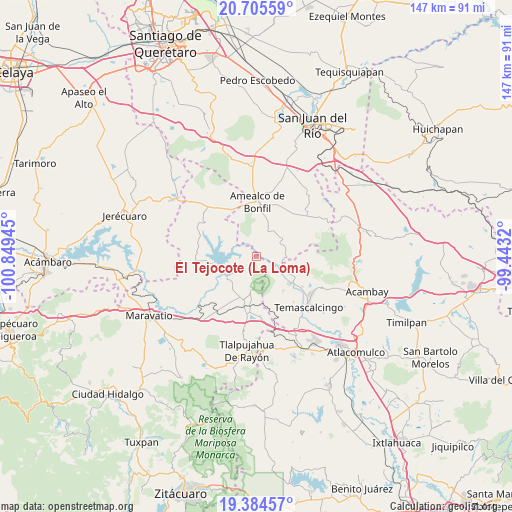
| Upper-left | 20.70559°, | -100.84945° |
| Center: | 20.04647°, | -100.14632° |
| Lower-right: | 19.38457°, | -99.4432° |
| Map W x H: | 146.9×146.9 km | = 91.3×91.3mi |
| max Lat: | 32.7° ⇑42.1% North |
| El Tejocote (La Loma): | 20.04647° |
| min Lat: | ⇓57.9% South 14.53588° |
| min Long | El Tejocote (La | max Long |
| -117.105° | -100.14632° | -86.73105° |
| W 34.2%⇐ | ⇒65.8% E |
Elevation
Elevation of El Tejocote (La Loma) is 2384 m = 7822 ft, and this is 1130.3 m = 3708 ft above average elevation for this country.
| Max E: |
3497 m = 11473 ft | 10.7% |
| El Tejocote (La Loma) | 2384 m 7822 ft | |
| Avg. | 1253.7 m = 4113 ft | |
Min E: |
-1 m = -3 ft | 89.3% |
See also: Mexico elevation on elevation.city.
Geographical zone
El Tejocote (La Loma) is located in North Torrid zone (between Equator and Tropic of Cancer). Distance of this Northern Tropic circle is 377 km =234.3 mi to North.| Distance of | km | miles | from El Tejocote (La Loma) |
|---|---|---|---|
| North Pole | 7778.1 | 4833.1 | to North |
| Arctic Circle | 5172.2 | 3213.9 | to North |
| Tropic Cancer | 377 | 234.3 | to North |
| Equator | 2229 | 1385 | to South |


Nearby cities:
15 places around El Tejocote (La Loma): (largest is in red/bold)
• Chitejé de Garabato
7.5 km =4.7 mi,  323°
323°
• Contepec
10.4 km =6.5 mi,  190°
190°
• Donicá
7.8 km =4.8 mi,  95°
95°
• El Lindero
6.1 km =3.8 mi,  13°
13°
• El Picacho
8.6 km =5.3 mi,  24°
24°
• El Varal
8.6 km =5.3 mi,  329°
329°
• Guadalupe el Terrero
8 km =5 mi,  359°
359°
• Llano Largo (Santa Rosa de Lima)
5.1 km =3.2 mi,  240°
240°
• San Antonio Molinos
7.9 km =4.9 mi,  294°
294°
• San Antonio Solís
8.2 km =5.1 mi,  129°
129°
• San Jose Solís
11.4 km =7.1 mi,  117°
117°
• San Nicolás de la Torre
5.9 km =3.7 mi,  53°
53°
• Santiago Mexquititlán Barrio 4to.
8.4 km =5.2 mi,  77°
77°
• Temascales (El Jacal)
2.6 km =1.6 mi, 289°
• Tepuxtepec
10.3 km =6.4 mi,  233°
233°
Sources, notices
• [Note1] Compared only with cities in Mexico existing in our database
• [Src1] Map data: © OpenStreetMap contributors (CC-BY-SA)
• [Src2] Other city data from geonames.org with taken over terms of usage.
• [Src3] Geographical zone / Annual Mean Temperature by Robert A. Rohde @ Wikipedia
