Ixtaczoquio geodata
Ixtaczoquio (Hidalgo) is a populated place; located in Mexico in America/Mexico_City (GMT-6) time zone. With population of 945 people, there are 9215 cities with bigger population in this country. Compared to other cities in Mexico, 75% of cities are located further ↓South; 60.4% of cities are located further ←West and 69.4% of cities have higher elevation than Ixtaczoquio. Note1


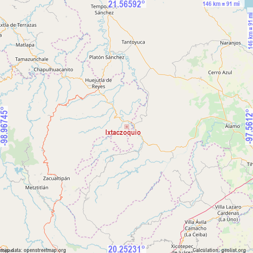
Ixtaczoquio GPS coordinates[2]
20° 54' 37.98" North, 98° 15' 51.552" West
| Map corner | latitude | longitude |
|---|---|---|
| Upper-left | 21.56592°, | -98.96745° |
| Center: | 20.91055°, | -98.26432° |
| Lower-right: | 20.25231°, | -97.5612° |
| Map W x H: | 146.1×146.1 km | = 90.8×90.8mi |
| max Lat: | 32.7° ⇑25% North |
| Ixtaczoquio: | 20.91055° |
| min Lat: | ⇓75% South 14.53588° |
| min Long | Ixtaczoquio | max Long |
| -117.105° | -98.26432° | -86.73105° |
| W 60.4%⇐ | ⇒39.6% E |
Elevation
Elevation of Ixtaczoquio is 449 m = 1473 ft, and this is 804.7 m = 2640 ft below average elevation for this country.
| Max E: |
3497 m = 11473 ft | 69.4% |
| Avg. | 1253.7 m = 4113 ft | |
| Ixtaczoquio | 449 m = 1473 ft | |
Min E: |
-1 m = -3 ft | 30.6% |
See also: Mexico elevation on elevation.city.
Geographical zone
Ixtaczoquio is located in North Torrid zone (between Equator and Tropic of Cancer). Distance of this Northern Tropic circle is 280.9 km =174.5 mi to North.| Distance of | km | miles | from Ixtaczoquio |
|---|---|---|---|
| North Pole | 7682 | 4773.4 | to North |
| Arctic Circle | 5076.1 | 3154.1 | to North |
| Tropic Cancer | 280.9 | 174.5 | to North |
| Equator | 2325 | 1444.7 | to South |


Nearby cities:
15 places around Ixtaczoquio: (largest is in red/bold)
• Acatepec
4.9 km =3 mi,  348°
348°
• Acatipa
0.7 km =0.4 mi,  359°
359°
• Ahuatitla
7.5 km =4.7 mi,  38°
38°
• Benito Juárez
6.6 km =4.1 mi,  113°
113°
• Calaco
8.6 km =5.3 mi, 108°
• Chiapa
5.5 km =3.4 mi,  234°
234°
• Chiatitla
7.1 km =4.4 mi,  265°
265°
• Ohuatipa
2 km =1.2 mi,  172°
172°
• Oxeloco
6.4 km =4 mi,  278°
278°
• Pohuantitla
6.8 km =4.2 mi, 226°
• Sasaltitla
7.5 km =4.7 mi,  68°
68°
• Tecacahuaco
8.5 km =5.3 mi,  293°
293°
• Texoloc
1.4 km =0.9 mi,  56°
56°
• Tlaltecatla
5.5 km =3.4 mi,  202°
202°
• Xochiatipan de Castillo
8.7 km =5.4 mi,  194°
194°
Sources, notices
• [Note1] Compared only with cities in Mexico existing in our database
• [Src1] Map data: © OpenStreetMap contributors (CC-BY-SA)
• [Src2] Other city data from geonames.org with taken over terms of usage.
• [Src3] Geographical zone / Annual Mean Temperature by Robert A. Rohde @ Wikipedia
