Calaco geodata
Calaco (Veracruz) is a populated place; located in Mexico in America/Mexico_City (GMT-6) time zone. With population of 623 people, there are 13874 cities with bigger population in this country. Compared to other cities in Mexico, 74.6% of cities are located further ↓South; 61.5% of cities are located further ←West and 70.9% of cities have higher elevation than Calaco. Note1


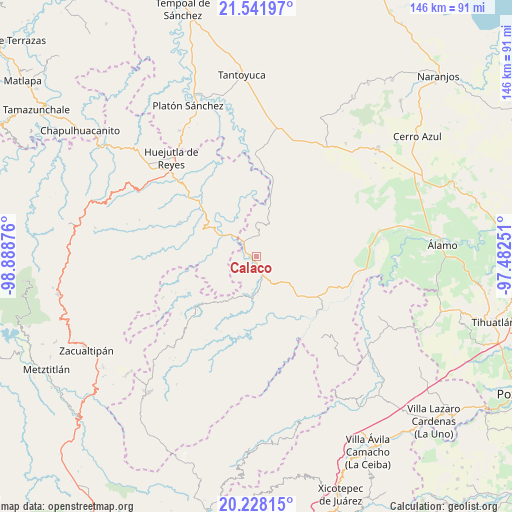
Calaco GPS coordinates[2]
20° 53' 11.4" North, 98° 11' 8.268" West
| Map corner | latitude | longitude |
|---|---|---|
| Upper-left | 21.54197°, | -98.88876° |
| Center: | 20.8865°, | -98.18563° |
| Lower-right: | 20.22815°, | -97.48251° |
| Map W x H: | 146.1×146.1 km | = 90.8×90.8mi |
| max Lat: | 32.7° ⇑25.4% North |
| Calaco: | 20.8865° |
| min Lat: | ⇓74.6% South 14.53588° |
| min Long | Calaco | max Long |
| -117.105° | -98.18563° | -86.73105° |
| W 61.5%⇐ | ⇒38.5% E |
Elevation
Elevation of Calaco is 375 m = 1230 ft, and this is 878.7 m = 2883 ft below average elevation for this country.
| Max E: |
3497 m = 11473 ft | 70.9% |
| Avg. | 1253.7 m = 4113 ft | |
| Calaco | 375 m = 1230 ft | |
Min E: |
-1 m = -3 ft | 29.1% |
See also: Mexico elevation on elevation.city.
Geographical zone
Calaco is located in North Torrid zone (between Equator and Tropic of Cancer). Distance of this Northern Tropic circle is 283.6 km =176.2 mi to North.| Distance of | km | miles | from Calaco |
|---|---|---|---|
| North Pole | 7684.7 | 4775 | to North |
| Arctic Circle | 5078.8 | 3155.8 | to North |
| Tropic Cancer | 283.6 | 176.2 | to North |
| Equator | 2322.4 | 1443.1 | to South |


Nearby cities:
15 places around Calaco: (largest is in red/bold)
• Acatipa
8.9 km =5.5 mi,  292°
292°
• Acatitla
7.8 km =4.8 mi,  353°
353°
• Ahuatitla
9.3 km =5.8 mi,  337°
337°
• Ahuica
5 km =3.1 mi,  10°
10°
• Alahualtitla
4.9 km =3 mi,  22°
22°
• Benito Juárez
2.1 km =1.3 mi,  269°
269°
• Hueycuatitla
2.3 km =1.4 mi,  153°
153°
• Ixtaczoquio
8.6 km =5.3 mi, 288°
• La Reforma
8.8 km =5.5 mi, 152°
• Ohuatipa
8 km =5 mi,  275°
275°
• Otlamalacatl
7.1 km =4.4 mi,  213°
213°
• Pemuxtitla
4.2 km =2.6 mi,  53°
53°
• Primo Verdad
7.8 km =4.8 mi,  203°
203°
• Sasaltitla
5.5 km =3.4 mi, 347°
• Texoloc
7.8 km =4.8 mi,  295°
295°
Sources, notices
• [Note1] Compared only with cities in Mexico existing in our database
• [Src1] Map data: © OpenStreetMap contributors (CC-BY-SA)
• [Src2] Other city data from geonames.org with taken over terms of usage.
• [Src3] Geographical zone / Annual Mean Temperature by Robert A. Rohde @ Wikipedia
