Acatepec geodata
Acatepec (Hidalgo) is a populated place; located in Mexico in America/Mexico_City (GMT-6) time zone. With population of 1,028 people, there are 8476 cities with bigger population in this country. Compared to other cities in Mexico, 75.8% of cities are located further ↓South; 60.2% of cities are located further ←West and 67.2% of cities have higher elevation than Acatepec. Note1


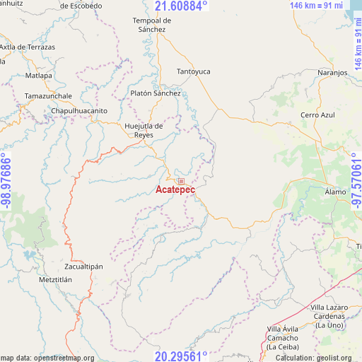
Acatepec GPS coordinates[2]
20° 57' 13.212" North, 98° 16' 25.428" West
| Map corner | latitude | longitude |
|---|---|---|
| Upper-left | 21.60884°, | -98.97686° |
| Center: | 20.95367°, | -98.27373° |
| Lower-right: | 20.29561°, | -97.57061° |
| Map W x H: | 146×146 km | = 90.7×90.7mi |
| max Lat: | 32.7° ⇑24.2% North |
| Acatepec: | 20.95367° |
| min Lat: | ⇓75.8% South 14.53588° |
| min Long | Acatepec | max Long |
| -117.105° | -98.27373° | -86.73105° |
| W 60.2%⇐ | ⇒39.8% E |
Elevation
Elevation of Acatepec is 571 m = 1873 ft, and this is 682.7 m = 2240 ft below average elevation for this country.
| Max E: |
3497 m = 11473 ft | 67.2% |
| Avg. | 1253.7 m = 4113 ft | |
| Acatepec | 571 m = 1873 ft | |
Min E: |
-1 m = -3 ft | 32.8% |
See also: Mexico elevation on elevation.city.
Geographical zone
Acatepec is located in North Torrid zone (between Equator and Tropic of Cancer). Distance of this Northern Tropic circle is 276.1 km =171.6 mi to North.| Distance of | km | miles | from Acatepec |
|---|---|---|---|
| North Pole | 7677.2 | 4770.4 | to North |
| Arctic Circle | 5071.3 | 3151.2 | to North |
| Tropic Cancer | 276.1 | 171.6 | to North |
| Equator | 2329.8 | 1447.7 | to South |


Nearby cities:
15 places around Acatepec: (largest is in red/bold)
• Acatipa
4.2 km =2.6 mi,  166°
166°
• Acatitla
8.2 km =5.1 mi,  88°
88°
• Ahuatitla
5.7 km =3.5 mi,  78°
78°
• Chiapa
8.8 km =5.5 mi,  203°
203°
• Chiatitla
8.1 km =5 mi,  229°
229°
• Coatzonco
5 km =3.1 mi,  323°
323°
• Huautla
8.7 km =5.4 mi,  351°
351°
• Huazalinguillo
5 km =3.1 mi,  31°
31°
• Ixtaczoquio
4.9 km =3 mi, 168°
• Ohuatipa
6.8 km =4.2 mi, 169°
• Oxeloco
6.6 km =4.1 mi, 234°
• Sasaltitla
8.2 km =5.1 mi,  104°
104°
• Tamoyón I
8.3 km =5.2 mi,  19°
19°
• Tecacahuaco
6.9 km =4.3 mi,  258°
258°
• Texoloc
4.6 km =2.9 mi,  152°
152°
Sources, notices
• [Note1] Compared only with cities in Mexico existing in our database
• [Src1] Map data: © OpenStreetMap contributors (CC-BY-SA)
• [Src2] Other city data from geonames.org with taken over terms of usage.
• [Src3] Geographical zone / Annual Mean Temperature by Robert A. Rohde @ Wikipedia
