Insurgentes geodata
Insurgentes (Veracruz) is a populated place; located in Mexico in America/Mexico_City (GMT-6) time zone. With population of 838 people, there are 10442 cities with bigger population in this country. Compared to other cities in Mexico, 60.5% of cities are located further ↓South; 75.8% of cities are located further ←West and 87.5% of cities have higher elevation than Insurgentes. Note1


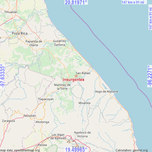
Insurgentes GPS coordinates[2]
20° 9' 39.888" North, 96° 55' 48.792" West
| Map corner | latitude | longitude |
|---|---|---|
| Upper-left | 20.81971°, | -97.63335° |
| Center: | 20.16108°, | -96.93022° |
| Lower-right: | 19.49965°, | -96.2271° |
| Map W x H: | 146.8×146.8 km | = 91.2×91.2mi |
| max Lat: | 32.7° ⇑39.5% North |
| Insurgentes: | 20.16108° |
| min Lat: | ⇓60.5% South 14.53588° |
| min Long | Insurgentes | max Long |
| -117.105° | -96.93022° | -86.73105° |
| W 75.8%⇐ | ⇒24.2% E |
Elevation
Elevation of Insurgentes is 32 m = 105 ft, and this is 1221.7 m = 4008 ft below average elevation for this country.
| Max E: |
3497 m = 11473 ft | 87.5% |
| Avg. | 1253.7 m = 4113 ft | |
| Insurgentes | 32 m = 105 ft | |
Min E: |
-1 m = -3 ft | 12.5% |
See also: Mexico elevation on elevation.city.
Geographical zone
Insurgentes is located in North Torrid zone (between Equator and Tropic of Cancer). Distance of this Northern Tropic circle is 364.2 km =226.3 mi to North.| Distance of | km | miles | from Insurgentes |
|---|---|---|---|
| North Pole | 7765.4 | 4825.2 | to North |
| Arctic Circle | 5159.5 | 3206 | to North |
| Tropic Cancer | 364.2 | 226.3 | to North |
| Equator | 2241.7 | 1392.9 | to South |


Nearby cities:
15 places around Insurgentes: (largest is in red/bold)
• Cementeras del Pital
4 km =2.5 mi,  63°
63°
• Ejido Vega de San Marcos
4.4 km =2.7 mi,  348°
348°
• El Guayabal
5.9 km =3.7 mi,  78°
78°
• El Pital
3.4 km =2.1 mi,  97°
97°
• Felipe Carrillo Puerto
3.6 km =2.2 mi,  218°
218°
• Guadalupe Victoria
1.8 km =1.1 mi, 64°
• Jicaltepec
8.5 km =5.3 mi, 83°
• La Defensa
7 km =4.3 mi,  207°
207°
• La Isla de Chapachapa
6.7 km =4.2 mi,  130°
130°
• La Reforma
3.6 km =2.2 mi,  174°
174°
• La Unión Paso Largo
7.6 km =4.7 mi,  253°
253°
• María de la Torre
7.7 km =4.8 mi,  242°
242°
• Máximo García
8.5 km =5.3 mi, 208°
• Puntilla Aldama
4 km =2.5 mi,  37°
37°
• San Rafael
7.2 km =4.5 mi, 64°
Sources, notices
• [Note1] Compared only with cities in Mexico existing in our database
• [Src1] Map data: © OpenStreetMap contributors (CC-BY-SA)
• [Src2] Other city data from geonames.org with taken over terms of usage.
• [Src3] Geographical zone / Annual Mean Temperature by Robert A. Rohde @ Wikipedia
