Guadalupe Victoria geodata
Guadalupe Victoria (Veracruz) is a populated place; located in Mexico in America/Mexico_City (GMT-6) time zone. With population of 2,481 people, there are 3565 cities with bigger population in this country. Compared to other cities in Mexico, 60.7% of cities are located further ↓South; 76% of cities are located further ←West and 93.5% of cities have higher elevation than Guadalupe Victoria. Note1


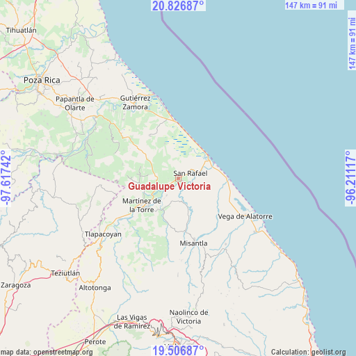
Guadalupe Victoria GPS coordinates[2]
20° 10' 5.772" North, 96° 54' 51.444" West
| Map corner | latitude | longitude |
|---|---|---|
| Upper-left | 20.82687°, | -97.61742° |
| Center: | 20.16827°, | -96.91429° |
| Lower-right: | 19.50687°, | -96.21117° |
| Map W x H: | 146.8×146.8 km | = 91.2×91.2mi |
| max Lat: | 32.7° ⇑39.3% North |
| Guadalupe Victoria: | 20.16827° |
| min Lat: | ⇓60.7% South 14.53588° |
| min Long | Guadalupe Victo | max Long |
| -117.105° | -96.91429° | -86.73105° |
| W 76%⇐ | ⇒24% E |
Elevation
Elevation of Guadalupe Victoria is 16 m = 52 ft, and this is 1237.7 m = 4061 ft below average elevation for this country.
| Max E: |
3497 m = 11473 ft | 93.5% |
| Avg. | 1253.7 m = 4113 ft | |
| Guadalupe Victoria | 16 m = 52 ft | |
Min E: |
-1 m = -3 ft | 6.5% |
See also: Mexico elevation on elevation.city.
Geographical zone
Guadalupe Victoria is located in North Torrid zone (between Equator and Tropic of Cancer). Distance of this Northern Tropic circle is 363.4 km =225.8 mi to North.| Distance of | km | miles | from Guadalupe Victoria |
|---|---|---|---|
| North Pole | 7764.6 | 4824.7 | to North |
| Arctic Circle | 5158.7 | 3205.5 | to North |
| Tropic Cancer | 363.4 | 225.8 | to North |
| Equator | 2242.5 | 1393.4 | to South |


Nearby cities:
15 places around Guadalupe Victoria: (largest is in red/bold)
• Cementeras del Pital
2.2 km =1.4 mi,  63°
63°
• Coapeche
9.3 km =5.8 mi,  172°
172°
• Ejido Vega de San Marcos
4.4 km =2.7 mi,  324°
324°
• El Guayabal
4.2 km =2.6 mi,  85°
85°
• El Pital
2.1 km =1.3 mi,  126°
126°
• Emiliano Zapata
9.3 km =5.8 mi,  329°
329°
• Felipe Carrillo Puerto
5.3 km =3.3 mi,  227°
227°
• Insurgentes
1.8 km =1.1 mi,  244°
244°
• Jicaltepec
6.8 km =4.2 mi, 88°
• La Defensa
8.5 km =5.3 mi,  214°
214°
• La Isla de Chapachapa
6.2 km =3.9 mi,  146°
146°
• La Reforma
4.6 km =2.9 mi,  196°
196°
• La Unión Paso Largo
9.4 km =5.8 mi,  252°
252°
• Puntilla Aldama
2.4 km =1.5 mi,  18°
18°
• San Rafael
5.4 km =3.4 mi,  65°
65°
Sources, notices
• [Note1] Compared only with cities in Mexico existing in our database
• [Src1] Map data: © OpenStreetMap contributors (CC-BY-SA)
• [Src2] Other city data from geonames.org with taken over terms of usage.
• [Src3] Geographical zone / Annual Mean Temperature by Robert A. Rohde @ Wikipedia
