La Isla de Chapachapa geodata
La Isla de Chapachapa (Veracruz) is a populated place; located in Mexico in America/Mexico_City (GMT-6) time zone. With population of 1,004 people, there are 8677 cities with bigger population in this country. Compared to other cities in Mexico, 59.6% of cities are located further ↓South; 76.2% of cities are located further ←West and 92.1% of cities have higher elevation than La Isla de Chapachapa. Note1
Current local time in La Isla de Chapachapa:
06:53 AM, WednesdayDifference from your time zone: hours


La Isla de Chapachapa GPS coordinates[2]
20° 7' 18.696" North, 96° 52' 55.488" West
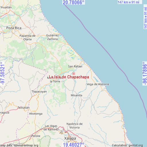
| Map corner | latitude | longitude |
|---|---|---|
| Upper-left | 20.78066°, | -97.58521° |
| Center: | 20.12186°, | -96.88208° |
| Lower-right: | 19.46027°, | -96.17896° |
| Map W x H: | 146.8×146.8 km | = 91.2×91.2mi |
| max Lat: | 32.7° ⇑40.4% North |
| La Isla de Chapachapa: | 20.12186° |
| min Lat: | ⇓59.6% South 14.53588° |
| min Long | La Isla de Chap | max Long |
| -117.105° | -96.88208° | -86.73105° |
| W 76.2%⇐ | ⇒23.8% E |
Elevation
Elevation of La Isla de Chapachapa is 19 m = 62 ft, and this is 1234.7 m = 4051 ft below average elevation for this country.
| Max E: |
3497 m = 11473 ft | 92.1% |
| Avg. | 1253.7 m = 4113 ft | |
| La Isla de Chapachapa | 19 m = 62 ft | |
Min E: |
-1 m = -3 ft | 7.9% |
See also: Mexico elevation on elevation.city.
Geographical zone
La Isla de Chapachapa is located in North Torrid zone (between Equator and Tropic of Cancer). Distance of this Northern Tropic circle is 368.6 km =229 mi to North.| Distance of | km | miles | from La Isla de Chapachapa |
|---|---|---|---|
| North Pole | 7769.7 | 4827.9 | to North |
| Arctic Circle | 5163.8 | 3208.6 | to North |
| Tropic Cancer | 368.6 | 229 | to North |
| Equator | 2237.3 | 1390.2 | to South |


Nearby cities:
15 places around La Isla de Chapachapa: (largest is in red/bold)
• Cementeras del Pital
6.3 km =3.9 mi,  346°
346°
• Coapeche
4.6 km =2.9 mi,  207°
207°
• El Guayabal
5.6 km =3.5 mi,  8°
8°
• El Pital
4.2 km =2.6 mi,  336°
336°
• Felipe Carrillo Puerto
7.4 km =4.6 mi,  282°
282°
• Guadalupe Victoria
6.2 km =3.9 mi,  326°
326°
• Insurgentes
6.7 km =4.2 mi,  310°
310°
• Jicaltepec
6.3 km =3.9 mi,  33°
33°
• La Defensa
8.4 km =5.2 mi,  257°
257°
• La Martinica
7.7 km =4.8 mi,  164°
164°
• La Reforma
4.7 km =2.9 mi, 279°
• Máximo García
9.6 km =6 mi,  251°
251°
• Palpoalanixcan
9.2 km =5.7 mi,  231°
231°
• Puntilla Aldama
7.9 km =4.9 mi, 340°
• San Rafael
7.6 km =4.7 mi, 11°
Sources, notices
• [Note1] Compared only with cities in Mexico existing in our database
• [Src1] Map data: © OpenStreetMap contributors (CC-BY-SA)
• [Src2] Other city data from geonames.org with taken over terms of usage.
• [Src3] Geographical zone / Annual Mean Temperature by Robert A. Rohde @ Wikipedia
