La Reforma geodata
La Reforma (Veracruz) is a populated place; located in Mexico in America/Mexico_City (GMT-6) time zone. With population of 513 people, there are 16399 cities with bigger population in this country. Compared to other cities in Mexico, 59.8% of cities are located further ↓South; 75.8% of cities are located further ←West and 93.5% of cities have higher elevation than La Reforma. Note1


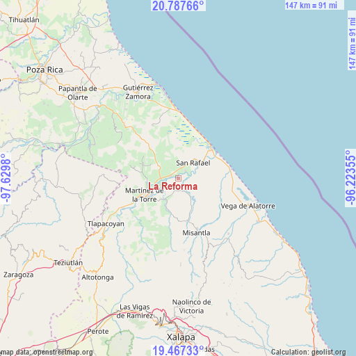
La Reforma GPS coordinates[2]
20° 7' 44.004" North, 96° 55' 36.012" West
| Map corner | latitude | longitude |
|---|---|---|
| Upper-left | 20.78766°, | -97.6298° |
| Center: | 20.12889°, | -96.92667° |
| Lower-right: | 19.46733°, | -96.22355° |
| Map W x H: | 146.8×146.8 km | = 91.2×91.2mi |
| max Lat: | 32.7° ⇑40.2% North |
| La Reforma: | 20.12889° |
| min Lat: | ⇓59.8% South 14.53588° |
| min Long | La Reforma | max Long |
| -117.105° | -96.92667° | -86.73105° |
| W 75.8%⇐ | ⇒24.2% E |
Elevation
Elevation of La Reforma is 16 m = 52 ft, and this is 1237.7 m = 4061 ft below average elevation for this country.
| Max E: |
3497 m = 11473 ft | 93.5% |
| Avg. | 1253.7 m = 4113 ft | |
| La Reforma | 16 m = 52 ft | |
Min E: |
-1 m = -3 ft | 6.5% |
See also: Mexico elevation on elevation.city.
Geographical zone
La Reforma is located in North Torrid zone (between Equator and Tropic of Cancer). Distance of this Northern Tropic circle is 367.8 km =228.5 mi to North.| Distance of | km | miles | from La Reforma |
|---|---|---|---|
| North Pole | 7768.9 | 4827.4 | to North |
| Arctic Circle | 5163.1 | 3208.2 | to North |
| Tropic Cancer | 367.8 | 228.5 | to North |
| Equator | 2238.1 | 1390.7 | to South |


Nearby cities:
15 places around La Reforma: (largest is in red/bold)
• Cementeras del Pital
6.2 km =3.9 mi,  31°
31°
• Coapeche
5.5 km =3.4 mi,  152°
152°
• Ejido Vega de San Marcos
8 km =5 mi,  351°
351°
• El Guayabal
7.2 km =4.5 mi,  49°
49°
• El Pital
4.3 km =2.7 mi,  43°
43°
• Felipe Carrillo Puerto
2.7 km =1.7 mi,  286°
286°
• Guadalupe Victoria
4.6 km =2.9 mi,  16°
16°
• Insurgentes
3.6 km =2.2 mi, 354°
• La Defensa
4.4 km =2.7 mi,  233°
233°
• La Isla de Chapachapa
4.7 km =2.9 mi,  99°
99°
• La Unión Paso Largo
7.8 km =4.8 mi,  280°
280°
• María de la Torre
7.2 km =4.5 mi,  270°
270°
• Máximo García
5.9 km =3.7 mi, 229°
• Palpoalanixcan
7 km =4.3 mi,  201°
201°
• Puntilla Aldama
7 km =4.3 mi, 17°
Sources, notices
• [Note1] Compared only with cities in Mexico existing in our database
• [Src1] Map data: © OpenStreetMap contributors (CC-BY-SA)
• [Src2] Other city data from geonames.org with taken over terms of usage.
• [Src3] Geographical zone / Annual Mean Temperature by Robert A. Rohde @ Wikipedia
