Vicente Guerrero geodata
Vicente Guerrero (Oaxaca) is a populated place; located in Mexico in America/Mexico_City (GMT-6) time zone. With population of 13,794 people, there are 705 cities with bigger population in this country. Compared to other cities in Mexico, 89.8% of cities are located further ↑North; 78.4% of cities are located further ←West and 53.8% of cities have lower elevation than Vicente Guerrero. Note1


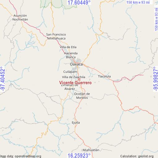
Vicente Guerrero GPS coordinates[2]
16° 55' 59.016" North, 96° 42' 5.004" West
| Map corner | latitude | longitude |
|---|---|---|
| Upper-left | 17.60449°, | -97.40452° |
| Center: | 16.93306°, | -96.70139° |
| Lower-right: | 16.25923°, | -95.99827° |
| Map W x H: | 149.6×149.6 km | = 93×93mi |
| max Lat: | 32.7° ⇑89.8% North |
| Vicente Guerrero: | 16.93306° |
| min Lat: | ⇓10.2% South 14.53588° |
| min Long | Vicente Guerrer | max Long |
| -117.105° | -96.70139° | -86.73105° |
| W 78.4%⇐ | ⇒21.6% E |
Elevation
Elevation of Vicente Guerrero is 1557 m = 5108 ft, and this is 303.3 m = 995 ft above average elevation for this country.
| Max E: |
3497 m = 11473 ft | 46.2% |
| Vicente Guerrero | 1557 m 5108 ft | |
| Avg. | 1253.7 m = 4113 ft | |
Min E: |
-1 m = -3 ft | 53.8% |
See also: Mexico elevation on elevation.city.
Geographical zone
Vicente Guerrero is located in North Torrid zone (between Equator and Tropic of Cancer). Distance of this Northern Tropic circle is 723.1 km =449.3 mi to North.| Distance of | km | miles | from Vicente Guerrero |
|---|---|---|---|
| North Pole | 8124.3 | 5048.2 | to North |
| Arctic Circle | 5518.4 | 3429 | to North |
| Tropic Cancer | 723.1 | 449.3 | to North |
| Equator | 1882.8 | 1169.9 | to South |


Nearby cities:
15 places around Vicente Guerrero: (largest is in red/bold)
• Animas Trujano
6.5 km =4 mi,  348°
348°
• Colonia 24 de Julio
1.1 km =0.7 mi,  160°
160°
• Colonia el Manantial
1.7 km =1.1 mi,  143°
143°
• Cuarta Sección
0.8 km =0.5 mi, 349°
• Emiliano Zapata
1.6 km =1 mi,  278°
278°
• Fraccionamiento Real del Valle
7.1 km =4.4 mi,  269°
269°
• Ninguno
1.4 km =0.9 mi,  197°
197°
• Reyes Mantecón
4 km =2.5 mi,  223°
223°
• San Bartolo Coyotespec
2.9 km =1.8 mi,  343°
343°
• San Juan Bautista la Raya
6.4 km =4 mi, 337°
• San Raymundo Jalpam
7.3 km =4.5 mi,  305°
305°
• Santa Catarina Quiané
7 km =4.3 mi, 216°
• Santa María Coyotepec
3.8 km =2.4 mi, 353°
• Trinidad Zaachila
6.8 km =4.2 mi,  258°
258°
• Villa de Zaachila
5.5 km =3.4 mi,  291°
291°
Sources, notices
• [Note1] Compared only with cities in Mexico existing in our database
• [Src1] Map data: © OpenStreetMap contributors (CC-BY-SA)
• [Src2] Other city data from geonames.org with taken over terms of usage.
• [Src3] Geographical zone / Annual Mean Temperature by Robert A. Rohde @ Wikipedia
